[3]
Quang Tri and Thua Thien, the northernmost provinces of the Republic of Vietnam, are more than 450 miles from Saigon, the capital. They are bordered on the north by the demilitarized zone, on the south by Quang Nam Province, on the east by the South China Sea, and on the west by the mountainous Laotian frontier.
Except for the narrow piedmont coastal plains, the terrain is dominated by hills and the Annamite Mountains. The highlands, characterized by steep slopes, sharp crests, and narrow valleys, are covered mainly by a dense broadleaf evergreen forest. Most of the peaks are from 4,000 to 7,000 feet high, but some rise above 8,000 feet. The narrow coastal plains flanking the highlands on the east are compartmented by rocky headlands and consist of belts of sand dunes and, in areas where the soil is suitable, rice fields.
From the crests that mark the drainage divide in the highlands, streams flow either east towards the South China Sea or west into Laos or Cambodia. Those flowing eastward are swift and follow short courses through deep narrow valleys over rocky bottoms until they reach the coastal plains, where they slow down and disperse over silty and sandy bottoms. The westward flowing streams follow longer traces, sometimes through deep canyons, other times through poorly drained valleys that, like the coastal plains in the east, are subject to seasonal flooding.
From a military point of view, operations were most affected by the rugged, forested mountains and hills, and the seasonally flooded lowland plains with their dense pattern of agricultural features. It was in the canopied forest, steep rugged mountains, dense undergrowth, and jungle along the demilitarized zone at the Rock Pile, Khe Sanh, and A Shau that much of the heavy fighting was to take place.
Weather played a dominant role in operations-particularly during the Tet offensive and subsequent operations at Khe Sanh and A Shau. The northeastern coast of South Vietnam and the adjacent Laotian panhandle are under the prevailing influence of a monsoon climate characterized by distinct wet and dry seasons.
4
Generally, the time of the southwest monsoon from May through September is a dry, hot, and dusty season in the mountain plateau and plains of the northeast coast. Across the mountains to the west in the Laotian panhandle, this same season brings heavy and frequent precipitation, high humidity, maximum cloudiness of the cumulus type permitting relatively good visibility and, except at the greater elevations, high temperatures. In contrast the northeast monsoon from November to mid-March carries the wet season to the coastal region of Vietnam while across the mountains in Laos the weather is hot and dry. During the wet season in the northern provinces temperatures often drop to 45 degrees, requiring issuance of warm clothing to the troops-an important logistical consideration.
Separating these major seasons are short transitional periods. From January through April the mountain plateau and northeast coast are also subject to the "crachin," a period of low cloud, fog, and drizzle or light rain which reduces ceilings and visibility. Another aspect of the weather is the combination of torrential rain and flash floods, which created flood conditions for units in base areas and on the march alike. The floods cost lives, damaged and destroyed property, and remained a contingency that commanders always had to be prepared to meet. In I Corps Tactical Zone both the northeast and the southeast monsoons exerted an influence on military operations unmatched elsewhere in Vietnam.
Transportation facilities in the region were poorly developed. Only one all-weather road, Route 9, connected the coast of Quang Tri province with the western mountains. In Thua Thien an extremely primitive road, Route 547, ran south and west from Hue into the A Shau Valley. The major north-south road was Highway 1, which ran north from the port of Da Nang in Quang Nam Province through the Hai Van Pass to Hue. From Hue the road continued north through the towns of Quang Tri and Dong Ha to Gio Linh, almost at the demilitarized zone, thence on into North Vietnam. North of the Hai Van Pass there were no all-weather ports. (Map 1)
By far the most important city in the region was Hue, the ancient imperial capital of Vietnam in Thua Thien Province about twelve kilometers from the sea. A city with a population of more than 100,000, it was the center of a serious Buddhist uprising in March of 1966.
The war in Vietnam was a fluid one with no front lines. The enemy was tough, versatile, tenacious, and cunning. He possessed strong entrenchments in the villages, mountain hideouts, and jungle redoubts. He was difficult to find and identify. At one end of the
5
MAP 1
spectrum he merged into the civilian population as an agent or guerrilla or civil official wearing no uniform, unarmed, and supported by a military political organization. At the other end of the spectrum he was a uniformed member of the regular North Vietnamese Army. The North Vietnamese and Viet Cong fighters possessed as much courage and motivation as any foe to face the American soldier. They proved a formidable adversary.
The composition of the U.S. military forces opposing the North Vietnamese was heterogeneous. The U.S. Marine Corps units were the first committed. As the enemy threat developed, U.S. Army artillery units were deployed north to reinforce the marines. The artillery was followed by other tactical, combat support, and combat service support elements, including a chemical smoke generator company. These, like the artillery reinforcements, came under
6
operational control of the commanding general of the III Marine Amphibious Force. The U.S. Navy provided logistical support for the marines from the sea as well as along the inland waterways. Air operations were undertaken by the Air Force, Navy, Marine Corps, and Vietnamese Air Force while the Army and Marine Corps furnished helicopter units.
It was necessary to integrate these diverse U.S. forces with the equally diverse Vietnamese forces that included the Army of Vietnam, Regional Forces, Popular Forces, Civilian Irregular Defense Group, Vietnamese Air Force, and Navy elements. All came under Vietnamese commanders responsive to headquarters in Saigon.
The demilitarized zone served as a line of demarcation between air and ground commanders. The air forces were responsible for the area north of the zone and the ground forces for the area south of it. Initially Marine ground elements had to obtain authority from the Air Force before firing counterbattery fire against North Vietnamese Army artillery just across the demilitarized zone and well within range of Marine Corps artillery. Later, responsibility for the area north of the zone was given to the Marine forces out to the range of their artillery, and thereafter, the U.S. Air Force coordinated with the ground troops prior to executing strikes in the area falling within range of the Marine artillery.
The Northern Border, 1965-1967
The first American combat forces were committed to the I Corps Tactical Zone in March of 1965 when two U.S. Marine battalions landed at Da Nang. Initially employed for the defense of the airbase at that city, the Marine battalions began limited offensive operations in April.
By the end of June 1965 the Marine strength had increased to seven battalions and was designated the III Marine Amphibious Force, under the command of Major General Lewis W. Walt, who also commanded the Third Marine Division. Operating from bases at Chu Lai, Da Nang, and Phu Bai near Hue, the Marines conducted operations against the enemy. The most successful of these, Operation STARLIGHT, resulted in the virtual destruction of two enemy battalions trapped against the South China Sea near Chu Lai.
By the spring of 1966, however, a new threat developed as the enemy began preparations for what appeared to be a major attack across the demilitarized zone. The enemy opened his offensive in March 1966 when the 95B and 101C Regiments of the North Vietnamese Army attacked a Special Forces camp located in the remote A Shau Valley in western Thua Thien province.
7
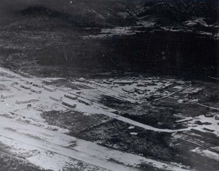
AERIAL VIEW OF A SHAU SPECIAL FORCES CAMP
After three days of valiant and heavy fighting in extreme weather, the Civilian Irregular Defense Group forces and a small detachment of U.S. and Vietnamese Special Forces abandoned the camp. Men of the Special Forces, Marine, Air Force, and Army helicopter units performed bravely in supporting and withdrawing these troops. Short of troops and helicopters and threatened by a major invasion along the demilitarized zone, General William C. Westmoreland, Commander, U.S. Military Assistance command, Vietnam, decided against reinforcing or reoccupying the remote camp of A Shau. Two years would pass before any Free World Forces would be able to return to this valley. After the United States abandoned the camp, North Vietnamese moved into the A Shau Valley and began to develop major logistical bases and to construct roads into Laos to tie in with the extensive network of trafficable routes leading from North Vietnam. During 1966, more than 58,000 men, the equal of five divisions, infiltrated South Vietnam. The enemy's strength throughout South Vietnam at the end of 1966 exceeded 280,000 and was augmented with an estimated 80,000 additional political cadre.
As the number of enemy personnel increased, so too did the
8
quality of enemy arms. A marked increase in the number of lightweight RPG2 rocket launchers which had been first employed in 1964 was noted. In attacks against the Special Forces camp at Khe Sanh and the Da Nang Airfield in January 1966, the use of 120-mm. mortars almost doubled the distance from which the enemy could conduct mortar attacks against these Free World installations. This ability sharply magnified U.S. base defense problems. Viet Cong and local guerrilla forces began to appear with the AK47, a Chinese Communist copy of the Soviet AK47 assault rifle, a highly effective automatic weapon.
U.S. commanders marked the infiltration of new enemy divisions and the stockpiling of equipment. In studying the enemy situation General Westmoreland concluded that the enemy intended to open a new front in northern I Corps to divert Free World Forces from the heavily populated region around Saigon which was the enemy's preferred objective. General Westmoreland also believed that the enemy hoped to seize and hold the northern areas as a base for a so-called liberation regime that could be parlayed into a winning "compromise" in future peace talks. The ultimate goal appeared to be the seizure of complete control of the two northern provinces, From the enemy point of view, the northern provinces of I Corps had advantageous features. Thua Thien province was in a state of critical political unrest, and the South Vietnamese government control of the province was severely challenged by dissident elements. From March until mid-summer of 1966, the government experienced a series of political crises as the Struggle Movement of militant Buddhists and students resorted to riots and civil disorders throughout the country; the situation was particularly acute in Hue and Da Nang.
The antigovernment movement was infiltrated by Communists and it appeared at the time to be taking over the northern portion of the country. In an effort to quell the trouble, the Saigon government removed the I Corps Commander, Lieutenant General Nguyen Chanh Thi, but mass protests nevertheless spread and continued until mid-summer.
Premier Nguyen Cao Ky flew to Da Nang in an attempt to end the rebellion there. In mid-April, a national political congress met in Saigon to adopt a program designed to meet the Buddhists' demands. The demonstrations soon ended, and by mid-May government troops regained control of Da Nang. Even so, the aftermath of bitterness and disaffection lingered, and the loyalty of many Vietnamese army troops in the northern region remained questionable since some had actively supported the rebel movement.
One other factor which drew the attention of the Communists
9
to northern I Corps was its proximity to North Vietnam and the subsequent need for shorter land routes for resupply and reinforcement.
In early 1966, the Communists transferred Quang Tri and Thua Thien provinces from their Region Five headquarters in the Central Highlands and placed them under Region Four, which included the area just north of the demilitarized zone in North Vietnam. This move was considered a possible indication that the Communists hoped to place the two provinces within North Vietnam's boundary as a bargaining point in any peace negotiations. The fact that the city of Hue is in one of these provinces was of considerable importance, and, to this day, Hue remains the traditional cultural and religious center of South Vietnam and of great psychological importance to the Vietnamese.
With North Vietnamese entering Quang Tri province from the north and west in divisional strength and with the U.S. Marines, U.S. Army, and South Vietnamese pushing north and west from the coast, a major clash seemed inevitable. The Free World Forces had watched the enemy buildup and advance closely from March through June and by mid-July were prepared to act.
Operation Hastings
The major clash between the allies and the invading North Vietnamese occurred in July 1966. For several weeks before this time Marine reconnaissance teams had been sighting groups of North Vietnamese near the village of Cam Lo in the east central part of Quang Tri Province. By early July reconnaissance teams in the Cam Lo area were almost invariably finding themselves in contact with large enemy units. Interrogation of prisoners and analyses of captured enemy documents confirmed that no fewer than 5,000 regulars of the 324B Division of the North Vietnamese Army were in South Vietnam, preparing to overrun Quang Tri Province.
To counter the coming attack General Walt, Commander of the III Marine Amphibious Force, had available only one reinforced Marine division, the Third, a Vietnamese Army division, the First, and some smaller Vietnamese Marine units. General Walt's other Marine division, the First, was fully occupied with security and pacification operations in southern I Corps.
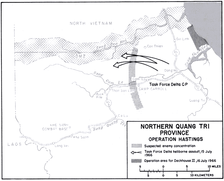
On July 11, the Marine and South Vietnamese commanders met in Hue to plan an operation to counter the enemy threat. The direct result was Operation HASTINGS, the largest operation of the war to date and one involving more than 8,000 Marines, 3,000 South Vietnamese, and perhaps as many as 12,500 enemy troops.
The operation, under the command of Brigadier General Lo-
10
MAP 2
well E. English, United States Marine Corps, began at 0800 on July 15 when the Marines executed a heliborne assault to secure landing sites to the rear of the North Vietnamese positions. (Map 2) The first lift enjoyed a relatively uneventful landing, but contact became heavy as subsequent lifts touched down. Using these contacts and intelligence acquired by reconnaissance units of both the Marines and Vietnam Army, the commanders were able to position forces in areas where they could achieve excellent results. Many enemy positions were overrun and large quantities of equipment, clothing, and other supplies were captured.
The enemy initially chose to stand and fight but soon revised his thinking and attempted to evade the Marine and Vietnamese Army forces. The marines uncovered several recently abandoned company-size bivouac areas with everything intact except the weapons, indicating that a large unit was probably trying to evade the task force. A regimental- or division-size command post was discovered with supplies for 500 men in the Dong Ha Mountains. It was surmised that Operation HASTINGS had pre-empted a major enemy attack. U.S. forces, together with the Vietnamese, had joined the battle with sufficient knowledge about the enemy to hold the initiative from the first day.
11
The Continuing Threat of Invasion
By the end of July the 324B Division was withdrawing across the demilitarized zone to North Vietnam. Certain elements of the division had suffered severely, but the division- itself remained intact. The North Vietnamese had been forced into action before they had completed their deployment, but they retained their unity and control. Other North Vietnamese units which had not been involved in the battle remained poised in remote mountain retreats or just across the border.
Late in August the 324B Division of the North Vietnamese Army returned to Quang Tri Province, positioning itself deep in the jungles of the western mountains. The Marines countered with Operation PRAIRIE, an extensive project designed to check the threat of another Communist move into the populated eastern region.
By October the marines had been forced to shift more of their forces north to the demilitarized area. Third Marine Division Headquarters was moved from Da Nang to Phu Bai near Hue with a forward command post at Dong Ha while the First Marine Division was stretched to cover all of I Corps south of Thua Thien.
12
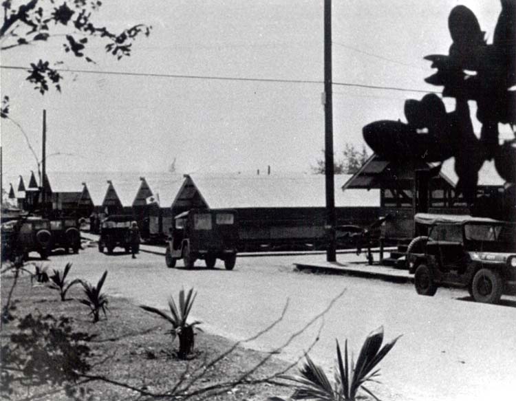
HEADQUARTERS, TASK FORCE OREGON, AT CHU LAI
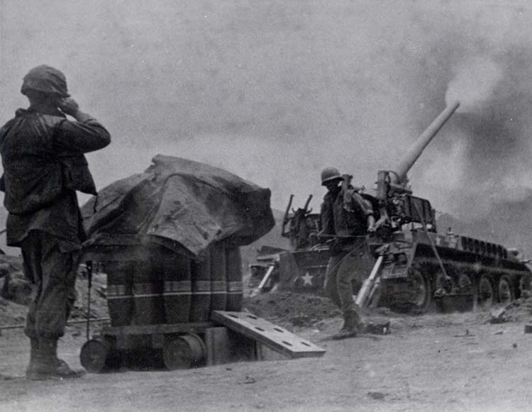
At this point the first U.S. Army combat units were introduced into the northern I Corps Tactical Zone. They consisted of several batteries with 175-mm. guns and 105-mm. self-propelled howitzers. These were employed to provide long-range fire support, bombardment into and across the demilitarized zone, or, in the case of the howitzers, direct support for ground troops. More substantial reinforcements would be needed if the northern provinces were to be held. The enemy had increased his forces in I Corps from 23 main force battalions in the summer of 1966 to 52 by the end of the year. General Walt, with his forces stretched to the limit and short of helicopter and logistical assets, was unable to do more than hold his own.
Planning for Reinforcements
During February and March of 1967 the level of combat rose sharply in the demilitarized zone area as the marines attempted to keep the enemy off balance. On 25 February General Westmoreland granted permission for the artillery of the III Marine Amphibious Force to fire against purely military targets in, and north of, the demilitarized zone. The enemy responded with a heavy
13
artillery barrage of his own against allied fire bases at Gio Linh, Con Thien, and Camp Carroll.
At this point, with intelligence sources indicating another major enemy offensive along the demilitarized zone, General Westmoreland instructed the staff of the Military Assistance Command, Vietnam, to prepare plans for a task force of four U.S. Army brigades, later reduced to three, with their appropriate supporting units, for deployment into I Corps.
When the enemy made several damaging attacks on Vietnamese Army units in the La Vang area in early April, General Westmoreland decided that the time for reinforcements had come. Major General William B. Rosson was assigned as commander of the new I Corps Task Force, designated Task Force OREGON.
Task Force Oregon
The organization and movement to the north of Task Force OREGON are worthy of some attention as the first deployment of large army units into I Corps. On 19 February General Rosson assembled a small group of officers and enlisted men to provide the nucleus of a planning staff for Task Force OREGON. This group immediately began operational and logistical planning in close coordination with III Marine Amphibious Force and U.S. Army, Vietnam. As the newly constituted staff began its work, General Westmoreland sent the major subordinate commands specific instructions outlining their roles in the plan.
While the task force planning staff proceeded with its work, the units that were earmarked to become a part of Task Force OREGON continued their normal operations. As the task force component elements were identified and mutual co-ordination and liaison established between units and planning staff, the units in no way disrupted their combat activities or altered operations underway. This formation of a provisional infantry division in a war zone while the component element of the new division continued to fight the war was in itself unique, and reflected a responsiveness, resourcefulness, and flexibility of Army leadership in meeting battlefield contingencies.
The brigades initially selected were the 1st Brigade, 101st Airborne Division, the 196th Light Infantry Brigade, and the 3d Brigade, 25th Infantry Division. The units had varying times of between 24 and 48 hours in which to assemble at different locations.
The provisional division was tailored to have basically the same capabilities as a standard infantry division. For simplicity in or-
14
ganization and ease in formation of the task force, the designated brigades with their organic battalions, separate companies, and detachments were adopted intact. Adjustments were made as necessary to insure that all capabilities of an infantry division were achieved. As an example, the 2d Squadron, 11th Armored Cavalry Regiment, was used as an infantry division cavalry squadron. Since the squadrons of the 11th Armored Cavalry did not have an organic air cavalry troop, Troop C of the 1st Squadron, 9th Cavalry, which was an air troop, was added to the troop list.
Similar steps to structure division support were taken by the planners in artillery and aviation. Engineer support requirements were met by combining the direct support engineer companies of each brigade with general engineer support increments from a combat engineer battalion. A provisional signal support battalion was also constructed by combining organic elements with attachments from the 1st Signal Brigade. The planning staff provision of military intelligence and military police support units followed the same pattern.
A unique method was used to establish combat service support for the provisional division. While an intact combat brigade could be taken out of an existing division, it was not feasible to lift a support command from a division, leaving the division without needed support. Fortunately the two independent brigades in the task force had their own organic division support, but there were no separate division size support commands available for inclusion in the new organization. As a result a tailored task force support command was created.
The units for the support command were drawn mainly from organizations, personnel, and equipment of the 1st Logistical Command. While these units were on duty with the task force, they lost their identity as 1st Logistical Command units and became Task Force OREGON troops. As such, they introduced several innovations, notably in the medical and aircraft maintenance areas, in providing logistical support for the task force.
The backup support to the task force, other than aircraft maintenance, was provided by the 1st Logistical Command through a general support group in the Chu Lai area. This group provided supply, maintenance, medical, and transportation support. When a brigade was to operate away from the Chu Lai base area, a forward support element was provided by the support group of the 1st Logistical Command. This command became the link with existing naval and Marine support elements in the area. Colonel Robert B. Pridgen, Commander of the Task Force Support Command, was responsible for providing backup support for the brigade
15
and direct support to all the units comprising the task force base other than the brigades.
The area selected to receive the task force already had a well-developed support complex that was capable of supporting the 30,000 troops expected to be located in the Chu Lai area. The facilities included an airstrip able to handle jets; four ramps for landing ships, tank (LST's); three ramps for landing ships, utility (LSU's); a barge discharge pier; and a pipe line for off-shore discharge of petroleum, oils, and lubricants. The Duc Pho area to the south was less well equipped. This southern portion of the Task Force OREGON area of operation lacked an airfield to handle the C-130, adequate landlines of communications, and sufficient beach and pier facilities. Since these limiting factors were noted during initial planning, only smaller-sized forces were assigned to the Duc Pho area until the difficulties could be surmounted.
Deployment of the task force to I Corps began on 12 April. The predesignated units and individuals of the task force assembled at specified airfields and ports for final equipping and preparation for transportation north. The deployment was made by battalion combat team increments to the Chu Lai airfield. The heavier equipped units proceeded by sea to the Chu Lai port. The Air Force provided C-130 sorties and the Navy furnished LST's. Careful scheduling paid off in the orderly and systematic arrival of many different units and increments from multiple departure points in II and III Corps Tactical Zones.
The deployment of the Army's Task Force OREGON to the southern part of I Corps permitted the marines to concentrate their forces further north where the enemy build-up was becoming ominous. On 26 April, the Commanding General, 1st Marine Division, turned over responsibility for the defense of the Chu Lai Airbase and logistics complex with the surrounding tactical area of responsibility to General Rosson, the Commanding General of Task Force OREGON.
Continuing Activity Along The Demilitarized Zone
As Army reinforcements deployed into southern I Corps, more and more Marine units were shifted north. Bases and logistical facilities in the demilitarized zone region were rapidly developed and expanded. Dong Ha, the largest of these installations, served as the command and control center for operations along the demilitarized zone. Eight miles southwest of Dong Ha was Camp Carroll, a large artillery base. Another smaller artillery base was located at the Rock Pile, ten miles west of Camp Carroll. Both of
16
MAP 3
these bases supported batteries of U.S. Army 175-mm. guns. The western anchor of the defense line was the Khe Sanh Combat Base near Dong Tri Mountain in the formidable Annamite Mountains. The principal eastern bases were Gio Linh and Con Thien just south of the Ben Hai River.
Throughout the following year the enemy concentrated his efforts first on western Quang Tri, then on the east, and then again on the west. His initial efforts in Quang Tri province centered around the Khe Sanh plateau, ideal terrain for the North Vietnam-
17
MAP 4
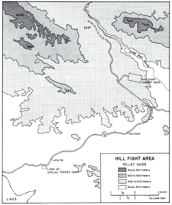
ese. The rugged mountainous countryside provided a natural infiltration route. Most of the mountain trails were hidden by three canopies of jungle up to 60 feet high, dense elephant grass, and bamboo thickets. Concealment from reconnaissance aircraft was good, and the heavy jungle undergrowth limited ground observation to five meters in most places. The most conspicuous terrain feature is Dong Tri Mountain, at 1,015 meters the highest peak in the region. Four smaller hillsHill 881 North, Hill 861, Hill 558, and Hill 881 Southdominated the main avenues of approach to the base. It was on and around these smaller hills that most of the significant battles were fought during the first phase of what was to become the long and stubborn struggle for Khe Sanh. (Map 3)
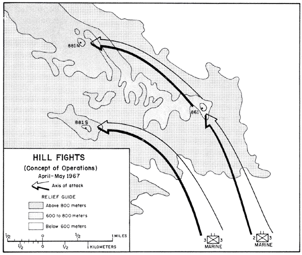
The battles began late in April when a Marine forward observer party became engaged with a large enemy force north of Hill 861. It is now believed that the marines prematurely triggered a major enemy attempt to overrun Khe Sanh. At least one regiment of the North Vietnamese 325C Division, it was soon discovered, was well dug-in in the vicinity of Hill 861 and was preparing to launch a ground attack against the combat base. In a series of hard-fought
18
battles known as "The Hill Fights" the Marine units, supported by massive air strikes and artillery, pushed the North Vietnamese out of the hill complex. Losses on both sides were heavy. The 325C was badly hurt and for a time presented no further threat to the Khe Sanh area. (Map 4)
The Battle for Con Thien
The action now shifted close to the eastern area of the demilitarized zone near the town of Con Thien, located two miles south of the zone. Con Thien was a small defensive position situated atop Hill 558, ten miles northwest on Dong Ha. From this perch, the marines had a commanding view of any activity in the area. The position was never manned by more than a reinforced battalion but always had from one to three battalions near by which could be used to outflank any enemy attempts to storm the strong point.
Con Thien was to become the anchor for the western end of a barrier six hundred meters wide extending eastward some eight miles to Gio Linh. This strip was to be a part of the strong point obstacle system and was to be bulldozed flat to aid in visual observation. Obstacles were to be used to canalize the enemy and to provide protection for the various electronic sensor devices placed along the strip to indicate the presence of some type of activity. Strong points such as Con Thien were to serve as patrol bases, fire support bases, and stations for monitoring the sensors.
Beginning in May 1967 the enemy made repeated attempts to capture or destroy the Marine base at Con Thien. The marines countered with Operation HICKORY a multibattalion sweep which soon developed into a number of fierce small unit engagements. The North Vietnamese opposing the marines were well-trained and well-equipped. Many were observed to be wearing flak jackets and steel helmets, and some employed flame throwers.
In July the enemy introduced a new weapon, the 152-mm. artillery piece. Fired from the demilitarized zone or from North Vietnam, it was the heaviest artillery weapon yet employed by the North Vietnamese. The marines countered with increased use of their own artillery, air strikes, and naval gunfire.
During September the enemy concentrated his attacks by fire against Con Thien itself. The shelling reached a peak during the week of 19-27 September when 3,077 mortar, artillery, and rocket rounds fell on the base. The Marine and Army artillery replied with well-executed counterbattery fire. This response, together with air strikes, appeared to give the enemy pause and his attacks slackened.
19
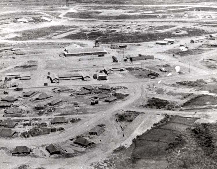
AERIAL VIEW OF KHE SANH IN QUANG TRI
Khe Sanh Again
While enemy activity abated in the east, it flared again in the western demilitarized area near Khe Sanh. During December, a surge of enemy activity in the area brought reports by Marine reconnaissance teams that large groups of North Vietnamese soldiers were moving into the area of the combat base. This time the enemy was not passing through but appeared to be moving in to stay. The number of clashes between Marine patrols and enemy units increased. The Marine companies that were dug-in on the outposts of Hill 881 S and Hill 861 reported receiving increased
20
enemy fire, and Khe Sanh base itself was subjected to probes along the perimeter. (Map 4) Reconnaissance sweeps turned up evidence that the enemy was entrenching; many caches of enemy supplies were found and fresh foxholes located. Trails giving evidence of recent heavy use were discovered. The year closed on an ominous note, with more and heavier fighting in the offing.
page created 15 January 2002