Chapter I:
The
Setting
- From the eastern seaboard of the United States the journey to the Republic
of Vietnam by merchantman takes thirty-four days nineteen days from the port
of San Francisco. The Asian country is bounded on the north by the Democratic
Republic of Vietnam, on the east by the South China Sea, on the southwest
by the Gulf of Thailand, and on the west by Laos and Cambodia.
-
- The tropical climate of the countryside changes with the seasonal monsoons.
At Saigon, the capital, the temperature varies little from an 84-degree average,
but the summer monsoon, gathering moisture over the Indian Ocean, brings heavy
rainfall to the southern city. From May through October fifty-eight inches
of rain may be expected. Farther north near the old imperial city of Hue 116
inches of rain may be expected toward the end of the year as the monsoon moves
farther northward and inland across Asia. Typhoons, or tropical cyclones which
originate in the Pacific, strike this sector between September and November,
bringing heavy rainfall and causing a great deal of damage at Hue and in its
neighboring Coastal plain.
-
- As the seasons change, the northeast monsoon, which originates in the interior
of Asia, sweeps across the expanses of China bringing clear skies and hot
dry weather. For a country of Vietnam's size, stretching as it does seven
hundred miles along its length and being as narrow as forty miles across the
17th parallel near the Demilitarized Zone, the seasonal differences are dramatic.
Summer weather prevails in the modern capital of Saigon from November to mid
March, while winter rains, mists, and tropical storms lash the ancient capital
at Hue.
-
- The long coastline, or eastern border, begins in the north at the Demilitarized
Zone, established as a result of the 1954 Geneva Accords, which created the
two Vietnams from the former French Indochina colony, and extends southwestward
in a gradual curve. The coastline consists of vast stretches of sand spotted
by irrigated rice paddies. The Annamite Mountains rise within thirty miles
of the coast in some places and as far back as seventy miles in others. The
land along the coast which is not covered by drifting sand
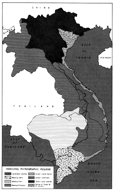
- [3]
- INDOCHINA PHYSIOGRAPHIC REGIONS
- [4]
- dunes is used for rice farming, although the coastal lands cannot compare
with the rich alluvial soil of the delta regions for productivity.
-
- The southernmost third of South Vietnam, the area sometimes known as the
delta or the rice basket, was once below sea level and therefore received
the rich alluvial deposits of the Mekong River. From prehistoric times the
richest soil in Asia has been deposited to form what is now the Ca Mau Peninsula
and the Plain of Reeds, or the Mekong and Saigon River Deltas. Some areas
in the delta have solidified, while others still remain marshy. The flat muddy
coast near the capital is representative of the area's silty clay, which is
hundreds of feet deep in places. Alluvial soil constitutes a blessing to the
rice grower, but a bane to the builder; when wet it becomes an unmanageable,
sticky mass with poor weight-bearing qualities. The region abounds with tributaries
and canals of which the French constructed some four thousand kilometers to
aid in the transformation of 4.3 million acres of swamp into arable land-a
feat surpassing the magnitude of digging for the Suez Canal.
-
- Much as the Mekong rambles to the sea in an apparently aimless wandering,
the Annamite Mountains (occasionally called the Annawese Cordillera) are a
sometimes rugged, sometimes flattened backbone pressing through much of Indochina
and forming the watershed between the Mekong River and the South China Sea.
In the north the range extends into North Vietnam, and in the south it becomes
the Central Highlands, a plateau area some one hundred miles wide and two
hundred miles long, covered, for the most part, with tropical forest. On the
east side the range rises steeply from the coastal plains. On the west it
gradually descends through a series of plateaus to the level of the Mekong
Delta. Because of the steep seaward slopes, the Cordillera forms a partial
barrier to inland penetration; and tribes distinct in race and culture from
the coastal Vietnamese continue to inhabit the mountains and highlands.
- (Map 1)
-
- The cultural history of the Vietnamese may be traced back to the early Neolithic
period. The original inhabitants of Vietnam founded their civilization along
the banks and in the delta of the Red River on the Tonkin Gulf very much the
way Egyptian civilization developed along the Nile. From the Red River and
its rice fields the population expanded. Several centuries of trading with
seafaring neighbors, resurgent wars, and invasions gave the people a history
deeply interwoven with warfare.
-
- The old kingdom of Annam in what is now the south predates the Second Punic
War. Chinese government had taken hold in Vietnam after the successful invasions,
of the Han dynasty, and
- [5]
- Annam or the "Dominion of the South" was thereafter molded and
dominated by the Chinese civilization. Revolts occurred during the period
of Chinese colonization which gave the Vietnamese many of their cultural folk
heroes and heroines. The country was unified between the eleventh and thirteenth
centuries and shortly thereafter repulsed the invasions of Kublai Khan only
to fall again to the Chinese in the fifteenth century. With a new dynasty
the Vietnamese were again their own masters and proceeded to establish military
colonies on the lands of their former masters. By the middle of the sixteenth
century the Nguyen family in Hue had firmly established their predominance
in the affairs of Annam.
-
- During the sixteenth century contact with the West began. Traders and missionaries
arrived to begin a modern era of intrigue. The French made their mark on the
people, and with the aid of the church and its lieutenants, the first French-supported
emperor gained the Annamese throne early in the nineteenth century. French
influence had its ups and downs until the latter half of the nineteenth century
when the French made their de facto conquest final, but Japanese conquest
in World War II upset French rule and resulted in a Vichy government followed
by a quasi independence for the Vietnamese. In 1946 the French attempted to
reassert their influence in Vietnam, and the resulting war was eventually
resolved in the Geneva Accords of 1954. It was during the 1954 Geneva Convention
that Vietnam was provisionally divided into two states.
-
- American involvement in the Vietnamese conflict began in the late 1940s
with arms aid to the French. Old alliances and the outbreak of the Korean
War placed the United States in a political position supporting French colonial
policy. In 1955 President Dwight D. Eisenhower, acting under extended provisions
of the Southeast Asia Treaty Organization (SEATO) protocol, pledged matériel
and advisory assistance to the South Vietnamese. As French Union forces left
Vietnam, American military advisory groups assumed the responsibility for
training the Vietnamese armed forces. In April 1961 -the Kennedy administration
signed a Treaty of Amity and Economic Relations declaring its intention to
render military aid to the Republic of Vietnam and "preserve its independence."
With this resolve, the American military presence in Vietnam increased to
four thousand officers and men by the end of 1962.
-
- The economy of Vietnam has suffered to a considerable extent throughout
its many years of strife, but rice continues to be the country's principal
export. Before World War II only two countries in the world exported more
rice than Vietnam, but continued war-
- [6]
- fare has changed the picture. The exportation of rubber from the huge southern
plantations has lost considerable importance since the widespread manufacturing
of synthetic rubber, but manioc, sweet potatoes, coconuts, and beans are still
exported. The Republic of Vietnam does not have the coal, zinc, tin, chrome,
phosphate, or lumber resources of the north. The populace must import most
of its heavy equipment and other manufactured goods.
-
- Local markets flourish in South Vietnam. Fish products, pigs, chickens,
rice, and small manufactured goods are bought and sold at hamlet and village
markets. The village, the second level of governmental hierarchy, still retains
the largest proportion of the 17.5 million Vietnamese population. A full 80
percent of the population remains scattered between district capitals and
any of the forty-four province capitals with the majority settled in the delta
or on the coastal plain between the country's principal railroad line and
the main north-south road. Farmers work their crops, and fishermen ply the
coastal waterways as do merchants in the small cargo vessels which transport
goods between the smaller coastal villages and the major port at Saigon, or
the minor ports at Hue or Nha Trang, or the old French naval port at Da Nang.
-
- Few major ports were ever built on the coast, since the economy of the area
has never lent itself to full exploitation and shipping has always been exposed
to seasonal typhoons and heavy winds during the winter monsoons. Deepwater
ports have been entirely unnecessary in Vietnam with the possible exception
of Saigon, which sits astride the Saigon River some forty miles inland. The
capital, fed by a continuing flow of junks, sampans, river boats, and steamers
coming down from upland and out of the Mekong, became the leading port for
domestic and foreign trade, since navigation in the delta region had been
improved by extended dredging and by canals which cut across swamplands and
cultivated fields to join together the many tributaries of the Mekong and
Saigon Rivers.
-
- In addition to being South Vietnam's primary seaport, Saigon had also been
the country's principal air terminal. As stop-off and refueling points -on
the international air lanes, Tan Son Nhut and nearby Bien Hoa outside of Saigon
were two of Vietnam's three airfields capable of accepting jet aircraft before
1965. Even as late as mid-1966 there were only six airfields capable of landing
jet aircraft, and only three of these employed high-intensity lighting. Radio,
navigation, and ground equipment were adequate only for existing civilian
traffic. The fact that Air Vietnam, the national airline, owned only thirteen
aircraft in 1965, none of which were jet powered, is a clue to the paucity
of Vietnam's airfield facilities.
-
- The most direct transportation available between major cities
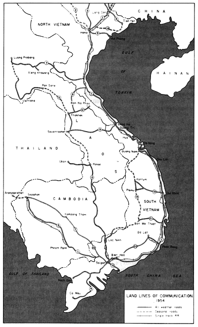
- [7]
- LAND LINES OF COMMUNICATIONS 1954
- [8]
- was by rail. The main line of the Vietnamese railroad system, once called
the Saigon-Hue-Hanoi Line, was completed in 1936, or fifty-five years after
it was begun. The right of way parallels the coast highway, cuts through mountain
spurs, and rises over rivers and streams, which lie shallow most of the year
but reach flood conditions during the monsoon. The former Trans-Indochina
Railroad, which originally comprised some 2,900 kilometers of narrow onemeter
gauge track, was the labor of two generations of French and Vietnamese engineers;
but for all practical purposes the line ceased to exist after 1965. It was
completely destroyed in many places by sabotage or left to fall into disrepair
because track security became virtually impossible.
-
- The Vietnamese road system received more attention than the railroad after
World War I. (Map 2) Main roads were constructed five to six meters
wide on level runs, but became narrower as they climbed into the mountains.
The vast number of bridges which were required imposed limitations on the
builders, although the most frequently constructed bridge was only two and
a half to three meters wide. Few roads were asphalted, some were macadamized,
but most roads were left unsurfaced. National Route 1, the main north-south
coastal highway, was originally very well constructed, since it was the principal
national road linking Hanoi in the north with Saigon in the far south. Route
13 was similarly constructed to link Saigon with Cambodia and Laos. Route
14, branching off Route 13, was built through the Central Highlands to join
Route 1 again at Da Nang. With secondary roads constructed to link smaller
political subdivisions together, the road system became quite adequate for
the limited volume and weight of traffic it had to sustain.
-
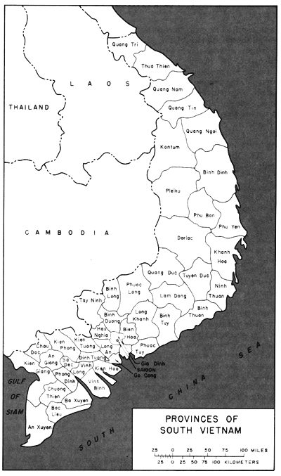
- The political subdivisions of the countryside from hamlet to village to
district and then to province had been satisfactory for civil government,
but the return to full-scale military operations and the need for military
lines of division and areas of responsibility caused a dividing of the political
map into larger military zones. (Map 3) Saigon was made into a military
district separate and distinct unto itself.- The northernmost five provinces
became I Corps Tactical Zone. The Central Highlands from Kontum and Binh Dinh
Provinces south through Quang Duc, Lam Dong, and Binh Tuy Provinces became
II Corps Tactical Zone. III Corps was cut out of the swamps with a southern
border of the Song Vam Co Tay, which runs across the narrow southern waist
of the republic. The heavily populated delta provinces made up IV Corps Tactical
Zone.
-
- With the steady increase in military activity and Vietnam's mobilization
for war, the military implications of the Vietnamese setting became matters
of prime concern to those who would be
- [9]
- PROVINCES OF SOUTH VIETNAM
- [10]
- responsible for carrying out tactical operations, providing logistic support,
and performing construction. The least significant factors of Vietnamese geography,
culture, climate, and habit assumed new dimensions and importance. The simple
matter of water supply illustrates the kind of problem which would soon have
to be dealt with.
-
- Most of the inhabitants of Vietnam obtain their water from streams, irrigation
canals and ditches, or shallow wells, which are often contaminated. In rural
areas these sources are used indiscriminately for laundry, watering animals,
cooking, and drinking. In the Mekong and Dong Na Deltas, tides cause waterways
to become brackish as far inland as sixty miles. Some wells in these areas
are drilled to a depth of 500 feet before a desirable stratum is reached.
Although the U S. Agency for International Development (USAID) began to sponsor
well-drilling for the Directorate of Water Supply, the Vietnamese had been
making do in the larger cities with a number of high-capacity deep wells begun
in the 1930s by the French.
-
- As a result of water supply and general sanitary conditions, the incidence
of waterborne diseases was particularly high. Military planning would have
to consider provisions for countering the problems of insect-transmitted diseases
like malaria, dengue, and encephalitis. Cholera, hepatitis, and typhoid were
common in the countryside because of a lack of trained medical personnel,
adequate medical facilities, and proper sanitation. Amoebic and bacterial
dysentery were as prevalent as tapeworm, hookworm, tuberculosis, and venereal
diseases.
-
- French Union troops had been affected by epidemics of schistosomiasis and
leptospirosis-parasitic infections of the intestines and bladder-between 1950
and 1954, and a full 25 percent of the personnel operating in the delta region
were finally debilitated. However, the incidence of these diseases could be
reduced by immunization and other preventive medicine programs as well as
by sanitary engineering. And the changing seasons had predictable effects
not only on the varieties of diseases which would become most threatening
at specified times but also on the kinds of military and engineering operations
that could most effectively be conducted.
-
- Layers of fine dust generated by heavy supply convoys traveling over unsurfaced
roads during the dry months become a thick impassable quagmire as the rainy
season begins. Heavy rainfall saturates and erodes all but the most carefully
compacted and protected soil. Unpaved runways and storage areas become unusable.
Lowland floods prevent cross-country movement by wheeled vehicles, and even
tracked vehicles become road bound. Small streams become
- [11]
- raging torrents washing out bridges, flooding over dams, carrying away roads,
and clogging culverts with silt and mud. Bivouac areas are flooded, and fields
of fire cleared during the dry months suddenly fill with lush foliage concealing
ground movement beyond friendly perimeters. The persistent moisture causes
shoe leather, tentage, and clothing to rot. Typhoons and squalls endanger
shipping at exposed anchorages, snap ship-to-shore fuel lines, and make unloading
operations virtually impossible. But the weather has the most significant
effect on flight operations.
-
- The dry season turns the countryside into a hot still oven. The dust generated
by helicopters, airplanes, trucks, and earth-moving equipment gets into everything.
Unless constant maintenance is carried on, dust wears out engines, clogs fuel
and lubrication systems, wears out delicate moving parts, and settles into
food and open wounds causing an entirely new series of infections and diseases.
Heat debilitates combat and construction troops, and work slows down.
-
- Troops whose mission is to operate in the mountains, along the coast, and
in camps deep in the delta region must be supplied and supported. Roads must
be made both safe from enemy interdiction and passable for heavily laden convoys.
The original Vietnamese roads had, however, deteriorated as a result of repeated
sabotage, lack of maintenance, and heavy usage. In width, alignment, and surfacing,
they could not possibly support the weight and volume of increased military
traffic.
-
- How were the U.S. forces and their allies to maintain thousands of miles
of roads, hundreds of bridges, and thousands of culverts without stationing
engineer units in compounds throughout the length and breadth of Vietnam?
How were they to support a complex modern army of half a million men without
ports and depots to receive, sort, and store supplies? Where would they house
this army and in what kind of structures? South Vietnam's lumber industry
was nonexistent and the country's mineral resources were very low. Even the
basic construction materials-sand, gravel, and rock-were not readily available.
-
- The very nature of the war required a military presence everywhere, and
that simply meant dotting the countryside with fire support bases, maneuver-element
base camps, logistic support areas, heliports, and tactical airstrips. The
nature of the war imposed a distinct need for jet airfields from which ground
support missions could be flown. And each base, airfield, and compound had
to be joined to its neighbor in an ever-expanding network of primary and secondary
roads.
- [12]
- page created 15 December 2001
Next Chapter
Return to the
Table of Contents