- Chapter V:
Plans and Operational
Procedures for the Mobile Riverine
Force
While the Army elements were being moved aboard the
ships of River Assault Flotilla One, the staffs of the flotilla and brigade
completed the planning for initial tactical operations. Lacking the unity of
organization for planning that is present in a joint staff, the brigade and
flotilla commanders informally agreed upon the planning roles of each staff.
Colonel Fulton and Captain Wells decided that Mobile
Riverine Force operations would be planned and conducted on the basis of
intelligence collected from areas in which major enemy forces were most
likely to be met and in which the abilities of a river force could be best
used. Once an enemy force and area had been agreed upon as a target by the
two component commanders, the brigade S-2 and flotilla N-2, working together
closely, would collect intelligence to support further planning. The N-2
would concentrate on the navigability of waterways and threats to the Navy
ships and assault craft. The S-2 would gather intelligence information
necessary to conduct land operations. Both the S-2 and the N-2 would be
highly dependent upon the intelligence disseminated by other U.S. and
Vietnamese headquarters because the Mobile Riverine Force had a large area
of interest and would need to move considerable distances from one location
to another.
Since the S-2 and N-2 could not supply all the information needed by the
riverine force, intelligence was obtained from several agencies. A seven-man
Mobile Intelligence Civil Affairs Team was formed by the brigade to
co-ordinate with these agencies. This team was formed from the brigade S-2
and S-5 sections, the prisoner of war interrogation team, the psychological
operations team, and military police platoons. It moved into the operational
areas of the force to collect intelligence from Vietnamese political
officials and from intelligence officers of military units. Working close
[89]
to the intelligence centers of Vietnamese organizations, the team aided
in the exchange of tactical intelligence as well as in the coordination of a
limited number of civil affairs activities. The Mobile Intelligence Civil
Affairs Team was not usually moved into an area during the planning phase of
an operation for fear of detection by enemy counterintelligence, but was
moved in at the beginning of an operation.
Another means of intelligence collection for the riverine force was the
riverine survey team. Controlled by Task Force 117, the team accompanied the
task force on missions and recorded depth soundings and clearance
measurements, thus providing reliable navigation data for subsequent
operations. Under the direction of the 9th Infantry Division engineer,
Vietnamese Regional and Popular Forces also collected information on bridges
so that the riverine force could be sure of vertical and horizontal bridge
clearance on a waterway.
While they were collecting information, the S-2 and N-2 briefed the
brigade and flotilla commanders and the planners on the area of the
impending operation, and this intelligence along with other information was
incorporated in planning guidance provided by the commanders. It was at the
point of the formulation of planning guidance that - the command
relationships of the Mobile Riverine Force received one of its greatest
tests. By close co-operation, Colonel Fulton and Captain Wells decided upon
the guidance to be issued to their staffs for each operation, and these
agreements in time came to be accepted as an informal set of standing
operating procedures. They were, however, subject to change at any time by
either commander and were not reduced to a written, formally approved
document. Task Force 117 published a standing order that contained the
results of considerable Army and Navy planning but was not jointly approved.
The brigade commander or a higher echelon Army commander usually selected
the enemy target and area of operations. The two commanders then agreed upon
the general task organization, the tentative duration and timing of the
operation, and the location of the mobile riverine base to support the
operation. The planning often included great detail in order to insure that
major issues were resolved early, permitting the two staffs to plan
efficiently.
From the outset, Colonel Fulton and Captain Wells recognized
[90]
the need to plan for future efforts while operations were in progress.
Colonel Turner, who lead been designated riverine adviser, acted as the
planning co-ordinator, with the assistant N-3 (plans) , the assistant S-3
(plans) , the N-2, and the S-2 forming the planning staff. The planning for
operations to take place ten days hence, the planning for the next
operation, three to five days hence, and the execution of the current
operation were accomplished at the same time, with the S-3 and N-3 dealing
with the current operation.
The planning staff, using the commanders' guidance, began by outlining
the scheme of maneuver in the objective area. From there the planners worked
backwards, covering in turn the landing or assault, water movement, and
loading phases. In preparing operations orders they took into consideration
factors peculiar to riverine operations such as tides, water depth, water
obstructions, bridge clearance, distance of the mobile riverine base from
beaches, availability of waterway routes into the area of operations,
suitability of river banks for landing sites, and mooring for barge-mounted
artillery. Operation orders followed the format of the standard,
five-paragraph field order, and were authenticated by the S-3 and the N-3.
The bulk of the information peculiar to riverine operations was in the
annexes, which included intelligence, operations overlay, fire support plan,
naval support plan, signal arrangements, logistics, civil affairs, and
psychological operations information. The intelligence annex supplied
information on terrain, weather, and the enemy situation. Waterway
intelligence was usually provided in an appendix that covered hydrography
and the enemy threat to assault craft. A map of the waterways to be used was
furnished, showing tides, widths and depths of streams, obstacles of various
types, bridges, shoals, mud banks, and other navigation data. The enemy
threat to assault craft was covered in descriptions of recent enemy action
along the waterways, location of enemy bunkers, kinds of enemy weapons
likely to be used in harassing action and ambushes, and water mine and
swimmer danger to the small boats. The operations overlay annex showed
schematically the area of operations, plan of maneuver, and control measures
such as checkpoints. The naval support plan annex contained the naval task
organization and referred to the operations order for information concerning
the situation, mission, and concept of operations. It assigned specific
support tasks to subordinate naval elements together with the necessary co-ordinating
instructions. An appendix to the naval support plan provided waterway data.
[91]
Battalion orders for operations in a riverine area followed the format
used in the brigade orders and were authenticated by the battalion S-3. The
supporting river assault squadron water movement plan was prepared by the
river assault squadron operations officer in co-ordination with the
battalion S-3. It was, in effect, the river assault squadron operations
order. This plan did not become a formal part of the battalion operations
order but was attached to it. The water movement plan contained the task
organization, mission, schedule of events, boat utilization plan, command
and communications instruction, and co-ordinating instructions. The schedule
of events paragraph listed events critical to the operation and the time
they were to take place, for example, where and when each unit was to load,
and its scheduled time of arrival at critical water checkpoints. The boat
utilization paragraph included numerical designations of boats and the
companies to embark on these boats. The co-ordinating instructions paragraph
included information on submission of reports, radio silence, recognition
lights, reconnaissance by fire, and the use of protective masks.
Once approved, both the brigade and battalion operations orders became
the authority for fulfilling the intent of the scheme of maneuver and for
providing combat and combat service support. Prior to each operation, a
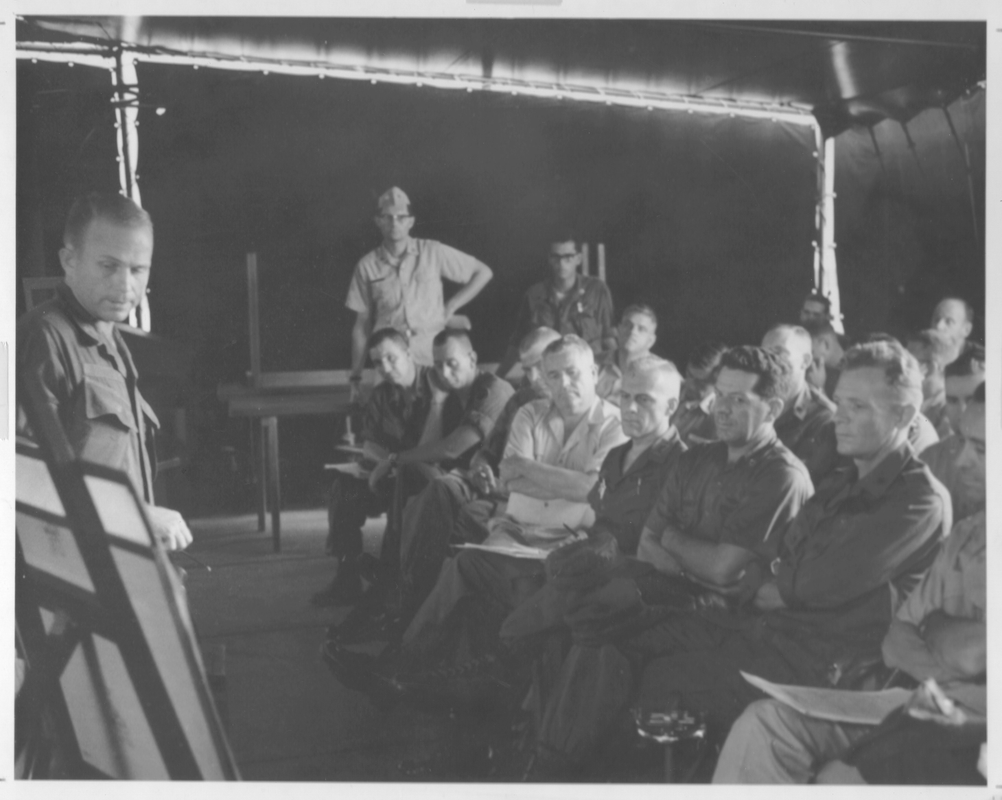
briefing was conducted on the flagship of the Mobile Riverine Force; it
included presentation of the plan of each battalion and squadron, as well as
the latest S-2 and N-2 intelligence. Briefings seldom required decisions by
the flotilla or brigade commander because problems had been resolved between
the Army and Navy elements at each subordinate echelon and between echelons
during planning. Beginning in June of 1967, plans and orders were in far
greater detail than the Army brigade and battalion commanders believed was
needed or even optimum for routine land warfare. The detailed nature of the
plan, however, included agreements at the Mobile Riverine Force command
level; the Navy commander desired to define clearly the tasks to be
performed by each service. For the Navy commanders and staffs, the detailed
plan was less objectionable, being similar to the planning associated with
amphibious, ship-to-shore operations. After June of 1967 as time passed both
Army and Navy commanders realized that matters such as the loading of a
battalion from a barracks ship onto the assault craft of a river assault
squadron and the configuration of a battalion river assault squadron convoy
were standing operating procedure. The Mobile Riverine' Force was
nevertheless to rely heavily on detailed operations orders
[92]
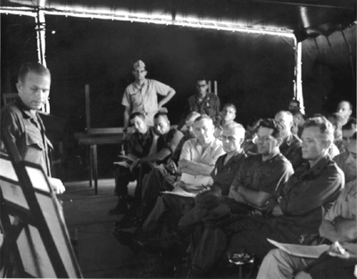
MOBILE RIVERINE FORCE BRIEFING ABOARD USS BENEWAH
rather than a formal, written standing operating procedure for many
months of its operations.
The initial operations of the Mobile Riverine Force during the period 1
June to 26 July 1967 were designated Operation CORONADO I. From 3 June
through 10 June operations were conducted in the vicinity of Dong Tam, and
were designed to make the land base more secure and to test the operational
procedures of the force. A tactical operations center manned jointly by the
Army and Navy provided a focal point for communications and for monitoring
operations and could fulfill the needs of the riverine brigade and flotilla
commanders separately.
At the levels of maneuver battalion and river assault squadron, the
staffs operated independently but maintained close, harmonious
relationships. The maneuver battalion staff Outranked and outnumbered the
river assault squadron staff. Because of a limited staff, the naval river
assault squadron was unable to perform staff functions which corresponded to
those of the infantry battalion it
[93]
supported. This limitation contributed to the centralization of planning
at the flotilla level. The two boat divisions organic to the river assault
squadrons also were limited in their planning. The rifle company commanders
transacted their business with naval enlisted men, who did not have .the
authority to make decisions. Time could be lost at the company and boat
division level in situations requiring quick decision.
Operations consisted of co-ordinated airmobile, ground, and waterborne
attacks, supported by air and naval forces. The ground and naval combat
elements traveled to the area of operations by river assault squadron craft,
helicopter; or a combination of these means. While the boats would serve as
a block and could transport troops in the early stages of an operation, once
the troops had engaged the enemy more speed was necessary and air
transportation of forces was generally more satisfactory.
The basic offensive maneuvers used by the Mobile Riverine Force were to
drive the enemy against a blocking force, with the open flanks covered by
Army helicopter gunships, or to encircle him. These maneuvers were based on
the estimate that the enemy would choose to fight only when he thought he
could inflict heavy casualties or when he was surprised and forced to fight.
If he chose not to fight, he might attempt to take advantage of the
concealment afforded by the numerous tree-lined waterways by dispersing into
small groups and leaving the area of operations under the protection of
small delaying and harassing fire teams. It was necessary for U.S. forces to
establish blocking positions quickly and to be able to deploy troops
rapidly. Several maneuver battalions were needed, but the Mobile Riverine
Force had usually only two battalions, a situation that provided further
incentive for co-ordinating operations with Vietnamese or other U.S. units.
Control of the riverine forces was aided by reliable and versatile
parallel Army and Navy communications systems, by operations conducted over
flat terrain by units within mutually supporting distances, and by command
helicopters used at the brigade and battalion levels. Troop movements were
controlled and co-ordinated from the flagship. The focal point for control
was the joint tactical operations center, the Army element of which was
under the supervision of the brigade executive officer. Staff representation
came from the S-3, S-2, N-3, air liaison, Army aviation, and artillery fire
support sections, and the center was operational at all times.
During operations the brigade employed a forward command group, usually
located at the fire support base, and composed of the
[94]
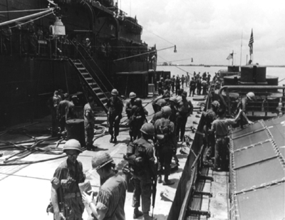
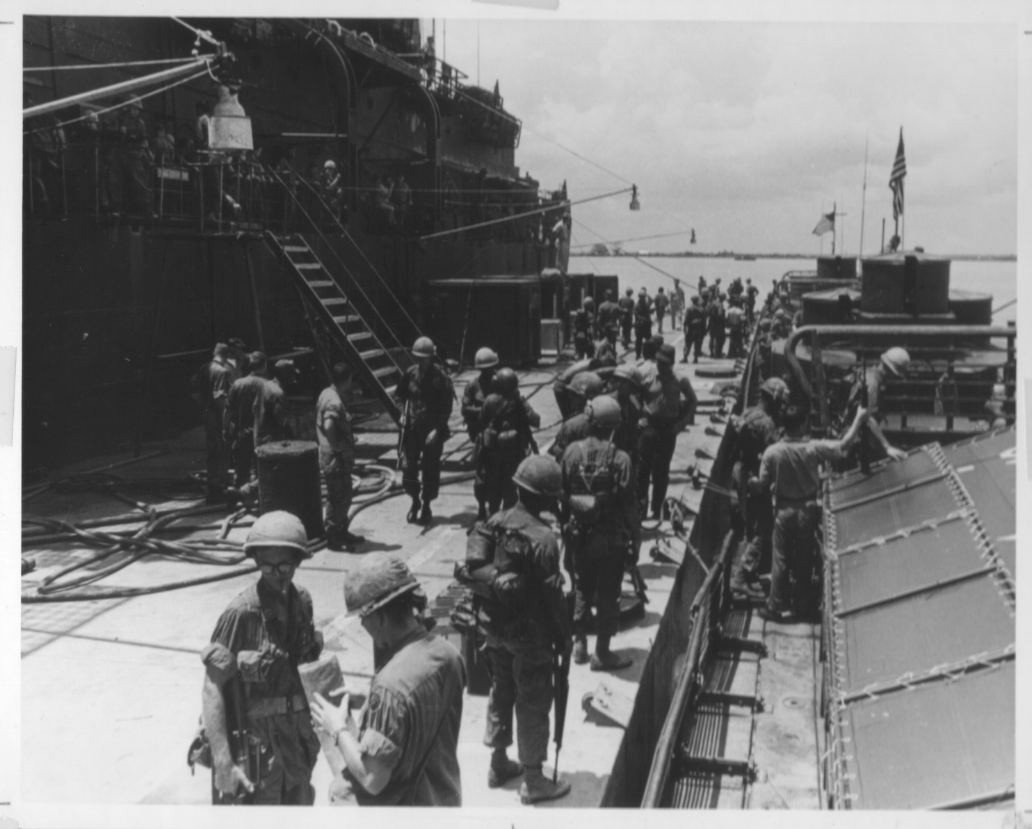
TROOPS PREPARE TO EMBARK FROM AMMI BARGES
brigade commander, the brigade S-3, the brigade assistant fire support
co-ordinator, and the air liaison officer. The brigade command group was
generally aloft in- a command helicopter in daylight hours. The battalion
command post was fragmented into a forward and a rear tactical operations
center. The forward post was located in a command boat that accompanied the
troops during their waterborne movement and normally consisted of the
battalion commander, S-3, assistant S-3, artillery liaison officer, an
operations sergeant, an intelligence sergeant, and two radio telephone
operators. The river assault squadron commander and his operations officer
were aboard the same command boat. The rear command post was located aboard
ship at the mobile riverine base and usually consisted of the battalion
executive officer, S-1, S-2, S-3, S-4, an operations sergeant, and two radio
telephone operators. When a command and control helicopter, usually an
observation type, was available, the battalion commander and his artillery
liaison officer controlled the operation from the air.
After the briefing that took place before each operation, battalion
commanders and supporting river assault squadron com-
[95]
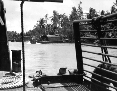
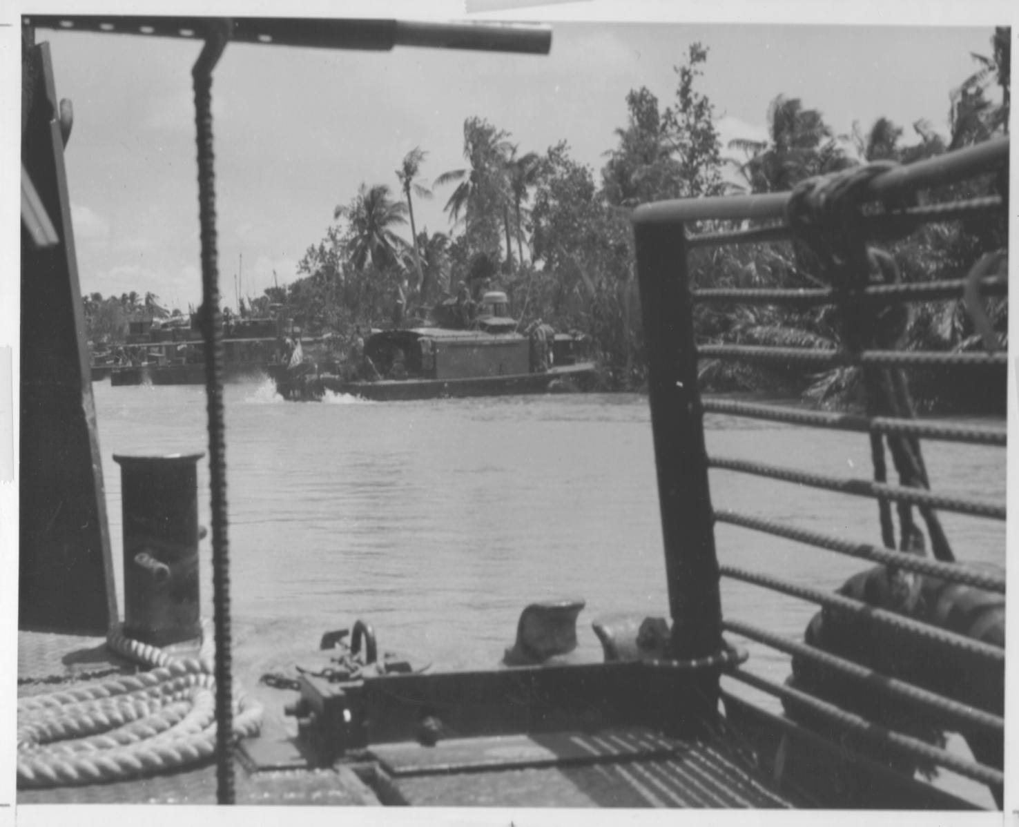
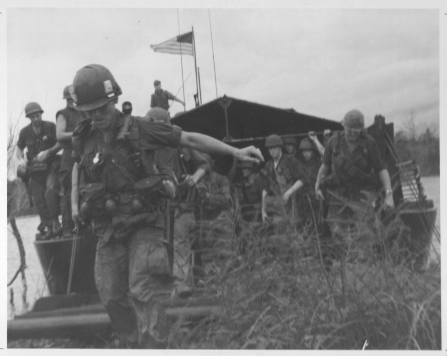
MONITORS AND ASSAULT PATROL BOATS HEAD IN TO SHORE
manders issued final instructions to their staffs and subordinate
commanders. These confirmed or modified previously issued orders. Each rifle
company was allocated three armored troop carriers, and arrangements were
made to load bulk cargo and ammunition prior to troop embarkation. At the
designated loading time for a particular company, three armored troop
carriers were tied alongside the Ammi barges moored to the ship and three
platoons of a company embarked simultaneously. In most instances, the
loading of a complete company was restricted to twenty minutes. The Navy
stationed expert swimmers on the barges prepared to rescue men who might
fall overboard. Once a company was loaded, the ATC's proceeded to a
rendezvous where they waited for the remainder of the battalion to load.
Upon completion of the battalion loading, the ATC's moved at a specified
time across a starting point and thence to the area of operation. Army
elements observed radio silence; the naval radio was used only for essential
traffic control.
The boats moved across the starting point in column formation, the
leading assault support boats providing minesweeping and fire support. Each
minesweeper was equipped with a drag hook that
[96]
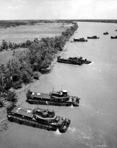
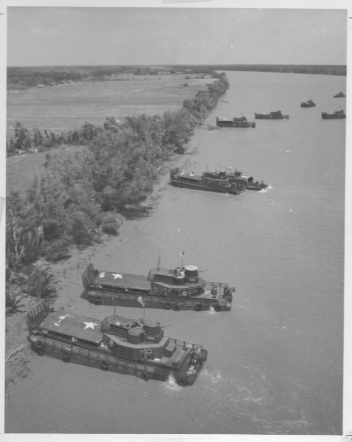
ASSAULT CRAFT GOING IN TO LAND TROOPS
was tethered with a steel cable to a high-speed winch. Two of the leading
minesweepers preceding on the flanks of the column dragged these hooks along
the bottom of the waterway in an effort to cut electrical wires rigged to
underwater mines. The river assault squadron commander traveled aboard the
leading command and control boat. The battalion commander was either in the
control boat or in a helicopter aloft. Each supporting river division was
[97]
divided into three sections, each section consisting of a monitor and
three ATC's supporting the one rifle company. These sections were in such
order in the column as to maintain infantry company integrity and to place
units on the beach in the order specified by the battalion commander. While
underway, the river assault squadron commander exercised command and control
of the boats. The rifle company commanders monitored the Navy command and
control and the battalion command net in order to stay abreast of developing
situations. Radar was the principal navigational aid during the hours of
darkness.
Water checkpoints were designated along the routes as a means of control,
and as march units passed these a report was made to the- joint tactical
operations center. Whether on large rivers or small streams, river assault
units were faced with the threat of hostile attack. However, when the boats
left the large rivers for the smaller waterways the danger from recoilless
rifles, rocket fire, and mines increased. The waterways negotiated by the
boats varied from a width of 100 meters where the smaller waterways joined
the river to widths of 15 to 25 meters. The formation that the boats assumed
was similar to that used on the main river except that the leading
minesweepers moved to positions nearer the column. While the column
proceeded along the small waterways, suspected areas of ambush (if in an
area cleared by the Vietnamese government) were often reconnoitered by fire
from the small boats and by artillery.
When the lead boats of the formation were approximately 500 meters from
the beach landing sites, artillery beach preparations were lifted or
shifted. The leading minesweepers and monitors then moved into position to
fire on the beaches on both sides of the waterway. This fire continued until
masked by the beaching ATC. If no preparatory fire was employed, the boats
landed at assigned beaches in sections of three, thus maintaining rifle
company integrity. Boats within a section were about 5 to 10 meters apart,
and a distance of 150 to 300 meters (depending on the beach landing sites
selected for each company) separated each boat section or assault rifle
company. After the units had disembarked, the boats remained at the beaching
site until released by the battalion commander. Upon release, the river
assault squadron craft either moved to provide fire support to the infantry
platoons or moved to interdiction stations and rendezvous points. Subsequent
missions for the boats included independent interdiction, resupply, and
extraction of troops.
[98]
TROOPS GO ASHORE FROM ARMORED TROOP CARRIER
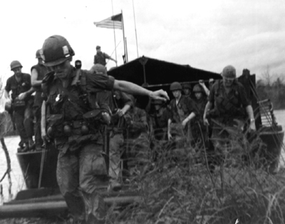
After landing the troops secured initial platoon and company
objectives and moved forward in whatever formation the terrain and mission
required. (Diagram 6) When contact with the enemy was made, commanders
immediately acted to cut off possible enemy escape routes. The most
frequently used tactic was to move units to blocking positions to the flanks
and rear of the enemy and direct extensive artillery fire, helicopter
gunship fire, and air strikes into the enemy positions. After this softening
up process, troops swept the area.
The Mobile Riverine Force had little trouble finding suitable helicopter
landing and pickup zones. Pickup zones used to mount airmobile operations
were normally located in the vicinity of the fire support base or on terrain
adjacent to the waterways. When there were not enough aircraft to move an
entire company at one time, platoons were shuttled into the area of
operations. The brigade standing operating procedure called for helicopter
gunships to escort each serial, and for an airborne forward air controller
to operate along the route of aerial movement.
[99]
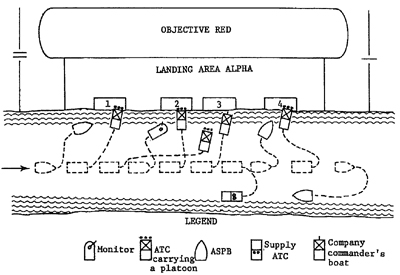
Diagram 6. Typical company landing formation.
During each day plans were made to arrive at a night defensive position
before dark unless troops were engaged with or pursuing the enemy. After
resupply, the night defensive position was organized against possible enemy
attack.
The fourth rifle company of each battalion was usually employed at the
fire support base under operational control of the base commander; for
mobile riverine base security it was under direct control of the Mobile
Riverine Base commander.
When the river-assault craft remained overnight on the small waterways in
the operational area, the brigade and battalion commanders planned for
security of the boats, which were usually kept near infantry elements
ashore. The boat fire was integrated with the fire of other units.
Withdrawal of riverine forces from the area of operations was
accomplished chiefly by boat. When units operated far inland from navigable
waterways, however, they were extracted by helicopter and taken to a landing
zone near a navigable waterway. They were then transported by boat to the
Mobile Riverine Base or to another area of operations. Sites designated for
picking up troops were often on streams lined with dense banana groves,
coconut groves, or nipa palm that made it difficult for both the ground unit
[100]
commander and the river assault squadron commander to spot. Ground and
water movement to the site was therefore controlled and co-ordinated from
the battalion commander's helicopter. The commander marked specific beach
and unit locations with colored smoke and directed the Army and Navy
elements to them by radio.
The same boat that was used to put an Army element ashore was also used
to bring it out. Each boat carried an identifying number and flew a
distinctive colored pennant from the mast that could be recognized by troops
who were behind dikes and vegetation. Each boat also carried three running
lights tiered near the top of the mast. Through the use of varying color
combinations in the top, center, and bottom running lights, the boat
designated for each boarding element could be readily identified.
Tides, draft, and maneuver room were primary considerations when boats
were scheduled to rendezvous with Army forces for pickup because tides not
only affected the water depth in canals, but caused significant changes in
current velocity and direction. Traveling a distance of thirty kilometers
upstream could take up to six hours against an ebbing tide, whereas the same
route might be covered in four and a half hours on an incoming tide.
The threat of ambush during troop removal was considered as great as
during movement to landings. When possible, an alternate to the route used
for entering an area was selected for picking up troops. Beaching of the
boats was usually accomplished with little difficulty because the
infantrymen on shore had reconnoitered the banks for obstacles. Army
security elements were placed 100 to 150 meters inland from the extraction
site. After the troops were aboard, the boats resumed tactical formation and
moved along the canal or stream and into the major waterway where the Mobile
Riverine Base was anchored.
During offensive operations, the commander of the Army element of the
Mobile Riverine Force in his position as base commander for all joint Army
and Navy bases was also responsible for the defense of the Mobile Riverine
Base. The Navy provided its appropriate share of forces, which included
those for gunfire support and protection against waterborne threats. Defense
of the base also involved arrangements for curfew and other restrictions for
water craft with appropriate Vietnamese civilian and military officials in
the immediate vicinity.
River assault divisions were assigned the responsibility for waterborne
defense on a rotating basis. They conducted patrols to control river
traffic, enforce curfews, and deter attack by water;
[101]
swept the vicinity of the Mobile Riverine Base for water mines; sent
demolition teams to inspect underwater anchor chains, hulls of ships, and
pontons for limpet mines; and dropped random explosive charges in the
anchorage area to deter enemy swimmers.
One rifle company under the base commander was responsible for shore
defense of the Mobile Riverine Base. Normally the company employed one
platoon on each bank of the river and held the remainder of the company in
reserve. Since anchorage space was 2,000 to 2,500 meters in length, it was
impossible to conduct a closely knit defense with the relatively small
number of troops committed. Platoon ambush sites were established on the
banks opposite the flotilla flagship and during daylight hours security
patrols were dispatched to provide early warning of enemy attack. The
security troops were reinforced as needed by elements of the company
defending the fire support base. Artillery and 4.2-inch and 81-mm. mortar
fire as well as fire from the boats was planned in support of the defense of
the base. The flat trajectory of naval weapons fire required careful
planning for both shore and waterborne defense.
The planning and operational procedures initially used by the Mobile
Riverine Force were refined as the staff and the force gained experience.
The first significant test of these procedures came during operations in
Long An Province in the III Corps Tactical Zone.
[102]
Page created 29 May 2001
Previous Chapter
Next Chapter
Return to the Table of Contents