![]()
| Search | Back Issues | Author Index | Title Index | Contents |
|
|
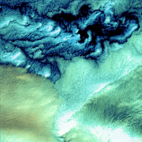
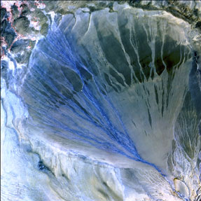
The collection being featured this month is at once a science site and a gallery of "found art". The sample images downloaded from the Earth as Art collection and shown here demonstrate why the site has been a popular one: the images are stunningly beautiful. The Earth as Art site went online on the Web in July 2002 with a set of images taken by the Landsat-7 satellite. The Landsat Program is administered jointly by the US Geological Survey (USGS) and NASA. In 2003, a second set of images was added to the gallery. This second set is composed of images taken from both Landsat-7 and the Advanced Spaceborne Thermal Emission and Reflection Radiometer (ASTER).
The images are in the public domain and may be reused. NASA only requests that each image used be displayed along with an image credit, as the images on this page are.
Large prints of the images are also available for purchase in print format from the USGS/EROS Data Center (http://edcw2ks15.cr.usgs.gov:8090/imagegallery/
The Earth of Art website contains a basic, understandable description of how satellite images differ from photographs, pointing out the difference between "true color" and "false color" images. The images in the Earth as Art gallery are "false color" images, whose colors were assigned by computers to what were originally black and white images captured by Landsat-7 and ASTER. "The three primary colors of light are red, green, and blue. Computer screens can display an image in three different bands at a time, by using a different primary color for each band." It is when the three images are combined that the "false color" image is created. These images have several uses, such as: coastal water mapping, vegetation monitoring, and study of soils, earth temperature, and weather, etc., that could not be done simply by studying photographs taken in the "true color" of the visible light spectrum. The Earth as Art site is maintained by the GSFC Laboratory for Terrestrial Physics, which advances NASA programs through the exploration of Earth and planetary solid-body physics. The web site designer is Maggie Masetti, the site curator is Laura Rocchio and the responsible NASA official for Earth as Art is Locke Stuart. The website is located at <http://landsat.gsfc.nasa.gov/earthasart/>.
Bonita Wilson |
||
Copyright© 2004 Corporation for National Research Initiativesdoi:10.1045/july2004-featured.collection |