- Chapter I:
-
- Operation Iceberg
-
- On 3 October 1944 American forces
in the Pacific Ocean Areas received a directive to seize positions in the
Ryukyu Islands (Nansei Shoto). Okinawa is the most important island of the
Ryukyu Group, the threshold of the four main islands of Japan. The decision
to invade the Ryukyus signalized the readiness of the United States to penetrate
the inner ring of Japanese defenses. For the enemy, failure on Okinawa meant
that he must prepare to resist an early invasion of the homeland or surrender.
-
-
- Operation ICEBERG, as the plan for
the Okinawa campaign was officially called, marked the entrance of the United
States upon an advanced stage in the long execution of its strategy in the
Pacific. Some 4,000 miles of ocean, and more than three years of war, separated
Okinawa from Pearl Harbor. In 1942 and 1943 the Americans had contained the
enemy and thrown him back; in 1944 their attack gathered momentum, and a series
of fierce island campaigns carried them toward the Japanese inner stronghold
in great strides.
-
- The Allied advance followed two main
axes, one through the islands of the Central Pacific, the other through the
South and Southwest Pacific. Navy task forces and some other elements operated
on both fronts as needed. The result was "unremitting pressure"
against Japanese military and naval might, a major objective of American strategy.
-
- Near the close of 1943, a thrust at
the Gilbert Islands from the Central Pacific, in which Tarawa, Makin, and
Apamama were seized, paved the way for the assault on the Marshalls on 31
January 1944. American forces captured Kwajalein, Majuro, and Eniwetok, and
their fleet and air arms moved forward. At the same time, American carriers
heavily attacked Truk, and that formidable enemy naval base in the Carolines
was thenceforth immobilized. Saipan, Tinian, and Guam in the Marianas fell
to American arms in the summer of 1944, and, in the First Battle of the Philippine
Sea, the U. S. Navy administered a crushing
- [1]
- defeat to the Japanese fleet that
tried to interfere with the American push westward. In September and October
the Americans occupied Ulithi in the western Carolines for use as an anchorage
and advanced fleet base, and took Angaur and Peleliu in the Palau Islands,
situated close to the Philippines.
-
- Meanwhile, American forces in the
South and Southwest Pacific were approaching Mindanao, southernmost of the
Philippine Islands, by advances through the Solomons and New Guinea in which
Japanese armies were neutralized and isolated on Bougainville, New Ireland,
and New Britain. The capture of Wakde on the northeastern coast of New Guinea
in May 1944 was followed by the seizure of Biak and Noemfoor. During the summer
a Japanese army attempting to break out from Wewak in Australian New Guinea
was subdued. The invasion of Morotai in September placed American forces within
300 miles of Mindanao.1
(See Map No. I.)
-
- The ultimate goal of American operations
in the Pacific was the industrial heart of Japan, along the southern shores
of Honshu between the Tokyo plain and Shimonoseki. American strategy aimed
to reach this objective by successive steps and to take advantage, on the
way, of Japan's extreme vulnerability to submarine blockade and air bombardment.
Throughout most of 1944 Army and Navy staffs in the Pacific Ocean Areas had
been planning for the invasion of Formosa (Operation CAUSEWAY) in the spring
of 1945. On the basis of the Joint Chiefs of Staff directive of March 1944,
the general concept of this operation had been outlined, the availability
of troops considered and reviewed many times, and the assignment of task force
commanders announced. On 23 August, a joint staff study for CAUSEWAY had been
published. It was clear that Admiral Chester W. Nimitz, Commander in Chief,
U. S. Pacific Fleet and Pacific Ocean Areas, intended to invade Formosa after
Southwest Pacific forces had established positions in the Central and Southern
Philippines; CAUSEWAY, in turn, was to be followed by operations against the
Ryukyus and Bonins, or against the China coast. Either course would lead eventually
to assault on the Japanese home islands.2
-
- On 15 September the Joint Chiefs directed
Gen. Douglas MacArthur to seize Leyte on 20 October, instead of 20 December
as planned, and to bypass
- [2]
- Mindanao. At the same time, Admiral
Nimitz was instructed to bypass Yap 3
On the next day Admiral Nimitz reconsidered the Formosa operation. He believed
that the early advance into the Central Philippines, with the opportunity
of acquiring the desired fleet anchorages there, opened up the possibility
of a direct advance northward through the Ryukyus and Bonins rather than through
Formosa and the China coast. He reviewed the objectives of CAUSEWAY the establishment
of air bases from which to bomb Japan, support China, and cut off the home
islands from resources to the south- with reference to the new possibility
and in a letter to his Army commanders requested their opinions on the subject.4
-
- Lt. Gen. Robert C. Richardson, Jr.,
Commanding General, U. S. Army Forces, Pacific Ocean Areas, replied that only
those steps should be taken which would lead to the early accomplishment of
the ultimate objective-the invasion of Japan proper. From this point of view
the occupation of Formosa as a stepping stone to an advance on Japan via the
China coast did not, in his opinion, offer advantages commensurate with the
time and enormous effort involved. He proposed instead, as a more economical
course, a dual advance along the LuzonRyukyus and the Marianas-Bonins axes.
He fully agreed with General MacArthur's plan to seize Luzon after Leyte.
The seizure of Luzon would provide air and naval bases in the Philippines
from which enemy shipping lanes in the China Sea could be blocked and, at
the same time, Formosa effectively neutralized. From the ample bases in Luzon,
it would be possible and desirable to seize positions in the Ryukyus for the
prosecution of air operations against Kyushu and Honshu. The occupation of
bases in the Bonins would open another route from the Marianas for bomber
operations against Japan. The air assaults on Japan would culminate in landings
on the enemy's home islands 5
-
- Lt. Gen. Millard F. Harmon, Commanding
General, U. S. Army Air Forces, Pacific Ocean Areas, in his reply to Admiral
Nimitz referred to a previous letter which he had written to the Admiral,
recommending, as an alternative to the invasion of Formosa and the China coast,
the seizure of islands in the Ryukyu chain, for development as air bases from
which to bomb Japan. He restated these views and emphasized his opinion that
if the objective of CAUSEWAY was the
- [3]
- acquisition of air bases it could
be achieved with the least cost in men and materiel by the capture of positions
in the Ryukyus.6
-
- The commander of the ground troops
designated for CAUSEWAY, Lt. Gen. Simon B. Buckner, Jr., Commanding General,
Tenth Army, presented the primary objection to the entire Formosa operation.
He informed Admiral Nimitz that the shortages of supporting and service troops
in the Pacific Ocean Areas made CAUSEWAY unfeasible. General Buckner added,
about a week later, that if an invasion of Luzon was planned the need for
occupying Formosa was greatly diminished. 7
-
- Admiral Nimitz communicated the substance
of these views to Admiral Ernest J. King, Commander in Chief, U. S. Fleet.
The latter, who had been the chief proponent of an invasion of Formosa, proposed
to the Joint Chiefs of Staff on 20ctober 1944 that, in view of the lack of
sufficient resources in the Pacific Ocean Areas for the execution of CAUSEWAY
and the War Department's inability to make additional resources available
before the end of the war in Europe, operations against Luzon, Iwo Jima, and
the Ryukyus be undertaken successively, prior to the seizure of Formosa. Favorable
developments in the Pacific and in Europe might make CAUSEWAY feasible at
a later date.8
On the next day, 3 October, the Joint Chiefs of Staff issued a directive to
Admiral Nimitz to seize one or more positions in the Ryukyu Islands by 1 March
1945.9
On 5 October Admiral Nimitz informed his command that the Formosa operation
was now deferred and that, after General MacArthur invaded Luzon on 20 December
1944, the Pacific Ocean Areas forces would seize Iwo Jima on 20 January 1945
and positions in the Ryukyus on 1 March. 10
-
- The projected Ryukyus campaign was
bound up strategically with the operations against Luzon and Iwo Jima; they
were all calculated to maintain unremitting pressure against Japan and to
effect the attrition of its military forces. The Luzon operation in December
would allow the Southwest Pacific forces to continue on the offensive after
taking Leyte. The occupation of Iwo Jima in January would follow through with
another blow and provide a base
- [4]
- MAP NO. 1
-
- [5]
- MAP NO. 2
-
- for fighter support for the B-29's
operating against Japan from the Marianas. The seizure of Okinawa in March
would carry the war to the threshold of Japan, cut the enemy's air communications
through the Ryukyus, and flank his sea communications to the south. Okinawa
was, moreover, in the line of advance both to the China coast and to the Japanese
home islands.11
-
- The direct advance to the Ryukyus-Bonins
line from the Luzon-Marianas was thus conceived within the framework of the
general strategy of destroying by blockade and bombardment the Japanese military
forces or their will to resist. The Ryukyus were within medium bomber range
of Japan, and it was estimated that 780 bombers, together with the necessary
number of fighters, could be based there. An advanced fleet anchorage was
available in Okinawa. From these airfields and naval bases American air and
naval forces could attack the main islands of Japan and, by intensified sea
and air blockade, sever them from the Japanese conquests to the south. The
captured bases could also be used to support further operations in the regions
bordering on the East China Sea. Finally,
- [6]
- the conquest of the Ryukyus would
provide adequate supporting positions for the invasion of Kyushu and, subsequently,
Honshu, the industrial heart of Japan. 12
-
-
- The Islands
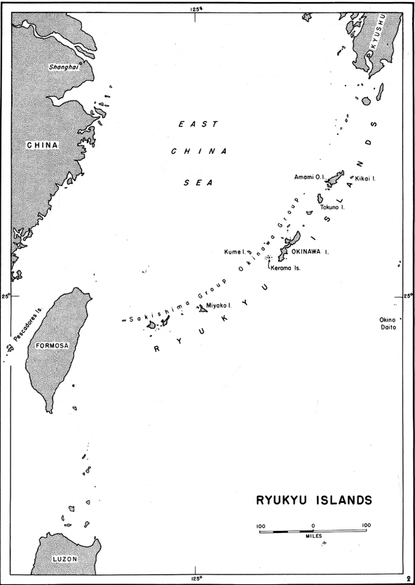
- The Ryukyu Islands lie southwest of
Japan proper, northeast of Formosa and the Philippines, and west of the Bonins.
(See Map No. l.) The islands, peaks of submerged mountains, stretch in an
arc about 790 miles long between Kyushu and Formosa and form a boundary between
the East China Sea and the Pacific Ocean. The archipelago consists of about
zoo islands, only 30 of which are large enough to support substantial populations.
The climate is subtropical, the temperature ranging from about 60° F. to 83°
F. Rainfall is heavy, and the high humidity makes the summer heat oppressive.
The prevailing winds are monsoonal in character, and between May and November
each year the islands are visited by destructive typhoons.13
-
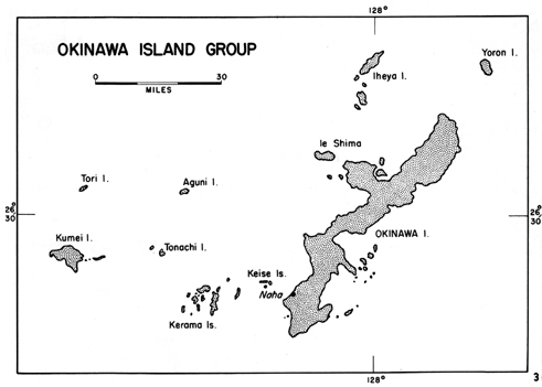
- Approximately in the center of the
arc is the Okinawa Group (Gunto) of some fifty islands clustered around the
island of Okinawa. The Kerama Islands lie in an area from ten to twenty miles
west of southern Okinawa. Kume, Tonachi, Aguni, and Tori form a rectangle
to the north of the Kerama Group. Ie Shima stands off the jutting tip of the
Motobu Peninsula on northern Okinawa, while farther to the north lie the Iheya
Islands and Yoron. A chain of small islands, called by the Americans the Eastern
Islands, extends along the eastern shore of southern Okinawa. Lying in the
path of the Japan Current, the entire Okinawa Group is surrounded by seas
warm enough to allow the growth of coral, and hence all the islands are surrounded
by fairly extensive reefs, some of which extend several miles off shore. (See
Map No. 2.)
-
- Okinawa is the largest of the islands
in the Ryukyus. Running generally north and south, it is 60 miles long and
from a to 18 miles wide, with an area of
- [7]
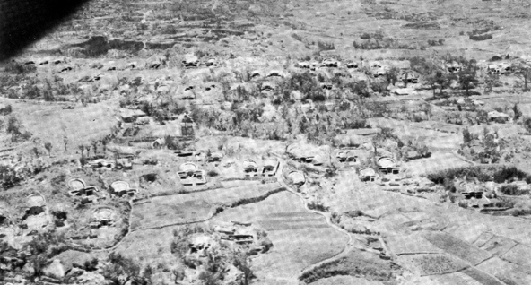
- burial tombs characteristics of the Okinawan landscape stand out
clearly in this aerial view
- (above) just north of Shuri.
-
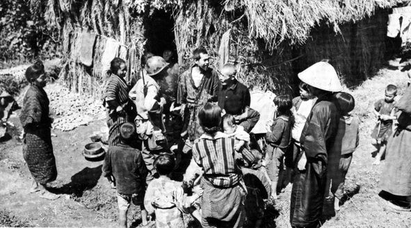
- OKINAWANS, their head man, and a native priest (white hat) gather
around an American
- soldier-interpreter as he ask questions
-
- [8]
- 485 square miles. It is entirely fringed
with reefs: on the western side the reef lies fairly close to shore and is
seldom over a mile wide; on the eastern side, where the coast is more sheltered,
the reef extends for some distance off shore, the widest and shallowest points
being north of Nakagusuku Bay. (See Maps Nos.II and III.)
-
- When Commodore Perry's ships sailed
into Naha Harbor, on 26 May 1853, Okinawa was a semi independent country,
paying tribute to China and Satsuma. It was annexed in 1879 by Japan, which
integrated the Okinawan people almost completely into the Japanese governmental,
economic, and cultural structure. The racial origins of the Okinawans are
similar to, but not identical with, those of the Japanese, and the Okinawan
stock and culture had been subject to extensive Chinese influence. While the
Okinawans generally resemble the Japanese in physique, they differ appreciably
in their language, the native Luchuan tongue. The predominant religion among
the Okinawans is an indigenous, animistic cult, of which worship of fire and
the hearth is typical; veneration of ancestors is an important element in
this religion and the burial tomb the most characteristic feature of the Okinawa
landscape a feature which the Japanese were to convert into a formidable defensive
position.
-
- The standard of living of the Okinawan
people is low; the Japanese made no attempt to raise it, regarding the Okinawans
as inferior rustics. Most of the inhabitants subsist on small-scale agriculture.
When the invading Americans climbed up from the beaches, they found every
foot of usable land cut into small fields and planted with sugar cane, sweet
potatoes, rice, and soy beans. In 1940 the population of the island was 435,000.
-
- The terrain in northern Okinawa, the
two-thirds of the island above the Ishikawa Isthmus, is extremely rugged and
mountainous. A central ridge, with elevations of 1,000 feet or more, runs
through the length of the region; the ridge is bordered on the east and west
by terraces which are dissected by ravines and watercourses, and it ends at
the coast in steep cliffs. About 80 percent of the area is covered by pine
forests interspersed with dense undergrowth. Troop movements are difficult
in the region as the use of vehicles is confined to the poor road that hugs
the western shore. The Motobu Peninsula, which is nearly square in shape and
juts to the west, has also a mountainous and difficult terrain. Two mountain
tracts separated by a central valley run east and west the length of the peninsula.
Successive coastal terraces are well developed on the north, east, and west
of the peninsula. About three and one-half miles off the northwest end of
the Motobu Peninsula is the small flat-topped island of Ie Shima, with a sharp
pinnacle about 500 feet high at the eastern end.
- [9]
- The southern third of Okinawa, south
of Ishikawa, is rolling, hilly country, lower than the north but broken by
terraces, steep natural escarpments, and ravines. This section is almost entirely
under cultivation and contains threefourths of the population of the island;
here, too, are the airfields and the large towns-Naha, Shuri, Itoman, and
Yonabaru. It was in this area that the battle for Okinawa was mainly fought.
The limestone plateau and ridges are ideal for defense and abound in natural
caves and burial tombs, easily developed into strong underground positions.
Generally aligned east and west, the hills offer no north-south ridge line
for troop movement, and thus they provide successive natural lines of defense,
with frequent steep slopes created by artificial terracing. Rice paddies fill
the lowlands near the coasts. The roads are more numerous than in the north,
but, with the exception of those in Naha and its vicinity, they are mostly
country lanes unsuited for motorized traffic. Drainage is generally poor,
and heavy rains turn the area into a quagmire of deep, clay-like mud.
-
- South of Zampa Point on the west there
is a 15,000-yard stretch of coast line which includes nearly 9,000 yards of
beaches, divided by the Bishi River. These are known as the Hagushi beaches,
deriving their name from a small village at the mouth of the river. The beaches
are not continuous but are separated by cliffs and outcropping headlands.
They range from 100 to 900 yards in length and from 20 to 45 yards in width
at low tide, and some are completely awash at high water. A shallow reef with
scattered coral heads borders the entire stretch of beach and, in many places,
is almost a barrier reef, with deeper water between its crest and the shore
line than immediately to seaward. The beaches are for the most part coral
sand and most have at least one road exit. A low coastal plain flanks the
beaches from Zampa Point south to Sunabe; it is dominated by rolling hills
which afford excellent observation, good fields of fire along the beaches,
and extensive cover and concealment. Less than 2,000 yards inland on the plain
lie the Yontan and Kadena airfields, north and south of the Bishi River. A
400foot-high hill mass, rising southeast of Sunabe and extending across the
center of the island, dominates the entire beachhead area. Composed of innumerable
sharp ridges and deep ravines, it is a major obstacle to rapid troop movements
and can be used effectively for a strong delaying action.
-
- South of the Sunabe hills, down to
the Uchitomari-Tsuwa line, the island narrows to 5,500 yards. The terrain
is essentially similar to that behind the Hagushi beaches, with heavily wooded
uplands and extensively terraced and cultivated valleys and lower slopes.
The hills and ridges are generally low except for some high peaks in the general
vicinity of Kuba on the east coast, from which observa-
- [10]
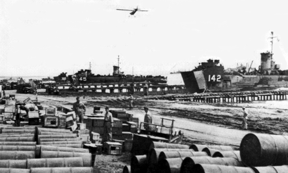
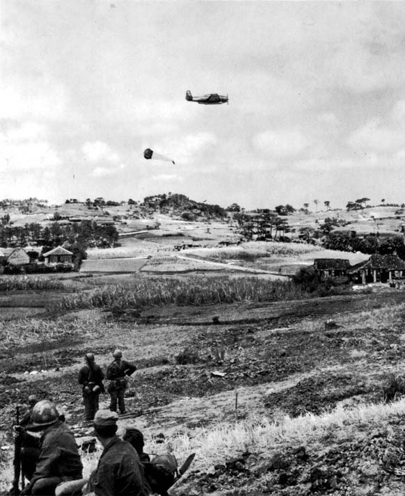
- OKINAWA'S LANDSCAPE in the south is marked by fields of grain and
vegetables,
- broken only by humps of coral, farmhouses, and villages. Navy plane
flying over such
- terrain is shown dropping supplies to the last fast-moving American
troops early in the campaign
-
- [11]
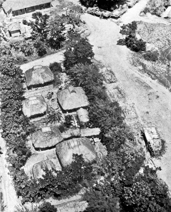
- VILLAGES ON OKINAWA consist of small clusters of houses surrounded
by vegetation-
covered stone and mud walls. Note camouflaged Japanese Army trucks
-
- [12]
- tion of the area is excellent. Roads
are adequate for light Japanese transport but not for the heavy strain of
American military traffic.
-
- On the east coast, the Katchin Peninsula
on the north and the Chinen Peninsula on the south extend into the ocean to
inclose the spacious fleet anchorage of Nakagusuku Bay, called by the American
troops "Buckner" Bay. A low coastal plain from one-fourth to one
mile wide runs along the shore of the bay from the Katchin Peninsula to Yonabaru.
At Yonabaru the plain extends inland to the west through an area of moderate
relief and joins another coastal flat extending northeastward from Naha. A
cross-island road follows this corridor and connects the two cities. Naha,
the capital of the island, with a population of 65,000, is Okinawa's chief
port and can accommodate vessels up to 3,000 tons. Southwest of the city,
on the Oroku Peninsula, was the Naha airfield, the most highly developed field
on the island.
-
- In the region north of the Naha-Yonabaru
corridor and in the vicinity of Shuri, the ancient capital of Okinawa, lies
the most rugged terrain in the southern part of the island. From the high
ground near Shuri and from many other vantage points in this area observation
is excellent to the north and south and over the coastal regions. At the highest
point the hills rise about 575 feet, but the lack of pattern, the escarpments,
steep slopes, and narrow valleys characteristic of the region make the major
hill masses ideal territory for defense. Many of the escarpments are sheer
cliffs without topsoil or vegetation. The low ground is filled with twisting
ridges and spotted with small irregular knolls, rendering observation difficult
and providing excellent locations for minor infantry and antitank positions.
The most prominent features of the region are the strong natural defensive
line of the Urasoe-Mura Escarpment, rising from the west coast above the Machinato
airfield and running for 4,500 yards across the island in a southeasterly
direction, and the chain of hills through Tanabaru and MinamiUebaru to the
east coast southwest of Tsuwa.
-
- South of the strong Shuri positions
the terrain is rough, but there are few large escarpments. There are some
broad valleys and an extensive road net which would facilitate troop movements.
The terrain in the southern end of the island consists of an extensive limestone
plateau, surrounded by precipitous limestone cliffs. The northern side of
the plateau is a 300-foot escarpment which rises vertically from the valley
floor in a jagged coral mass. On the top of the plateau major hills-Yuza-Dake
and Yaeju-Dake-cover all approaches from the north, east, and west. Along
the southeastern coast, much of the stretch from Minatoga to the eastern end
of the Chinen Peninsula consists of beaches.
- [13]
- These are dominated by the rolling
dissected terrace forming the body of the peninsula and by the high plateau
to the southwest.
-
- American Intelligence of the Enemy
- American knowledge of the enemy and
of the island of Okinawa was acquired slowly over a period of many months
and in the face of many difficulties. With Okinawa isolated from the world
by the Japanese, information of military value concerning this strategic inner
defense line of the Empire was scarce and difficult to obtain. Limited basic
intelligence was garnered from documents and prisoners captured on Pacific
island battlefields, from interrogation of former residents of the Ryukyus,
and from old Japanese publications. The great bulk of the data was obtained
through aerial photographic reconnaissance. This, however, was often incomplete
and inadequate, particularly for terrain study and for estimating enemy strength
and activity. The distance of the target from American air bases-1,200 nautical
miles-necessitated the use of B-29's and carrier planes for photographic missions;
the former afforded only high-altitude, small-scale coverage, while the latter
depended on the scheduling of carries strikes. The relatively large land masses
involved and the prevalence of cloud cover added to the difficulty of obtaining
the large-scale photographs necessary for detailed study of terrain and installations.14
-
- The target map prepared by American
intelligence represented all that was known of the terrain and the developed
facilities of the island. This map, scale 1 : 25,000, was based on aerial
photographs obtained on 29 September and 10 October 1944 and was distributed
about 1 March 1945. Incomplete coverage, varying altitudes of the planes,
and cloudiness over parts of the island at the time prevented clear delineation,
and certain portions of the map, including that of the high ground north of
Shuri, had either poor topographic detail or none at all. Additional photographic
coverage of the island was obtained on 3 and 22 January, 28 February, and
1 March 1945; that of 22 January was excellent for the proposed landing beach
areas. To supplement aerial photography a submarine was sent from Pearl Harbor
to take pictures of all Okinawa beaches. The submarine never returned.15
- [14]
- Hydrographic information was complete,
but its accuracy could not be checked until the target was reached. As the
data agreed with a captured Japanese map they were presumed to be accurate.
The most reliable information on the depth of the water over the reefs was
obtained from Sonne Strip photography and was made available to the troops
in March.16
-
- The first estimate of enemy strength,
made in October 1944, put the number of Japanese troops on Okinawa at 48,600,
including two infantry divisions and one tank regiment.17
In January 1945 this estimate was raised to 55,000, with the expectation that
the Japanese would reinforce the Okinawa garrison to 66,000 by 1 April 1945.
At the end of February, however, the January estimate was still entertained.
All these figures were based on interpretation of aerial photographs and on
the use of standard Japanese Tables of Organization: there was no documentary
evidence corroborating the estimate of the number of troops on the island.
18
-
- It was believed that the Japanese
had moved four infantry divisions to the Ryukyus during 1944. These were identified
as the 9th, 62d, 24th, and 28th Divisions. Army intelligence learned that
one division, perhaps the 9th, had been moved from Okinawa to Formosa in December
1944. In March 1945 American intelligence estimated that the Japanese forces
on Okinawa consisted of the following troops, which included 26 battalions
of infantry
| Headquarters 32d Army |
625 |
| 24th Division (triangular) |
15,000-17,000 |
| 62d Division (square) |
11,500 |
| 44th Independent Mixed Brigade |
6,000 |
| One independent mixed regiment |
2,500 |
| One tank regiment |
750 |
- One medium artillery
regiment, two mortar battalions, one anti-
- tank battalion, three
antitank companies, and antiaircraft
- units
|
5,875 |
| Air-ground personnel |
3,500 |
| Service and construction
troops |
5,000-6,000 |
| Naval-ground troops |
3,000 |
| Total |
53,000-56,000 |
-
- [15]
- It was considered possible that elements
of the 9th and 28th Divisions might also be present on Okinawa
proper. Enemy forces were known to be organized under the 32d Army,
commanded, it was thought, by General Watanabe, with headquarters at Naha.
Shortly before the landings the estimate of Japanese troops was raised to
65,000 on the basis of long-range search-plane reports of convoy movements
into Naha.19
-
- Calculations based on Japanese Tables
of Organization indicated that the enemy could be expected to have 198 pieces
of artillery Of 70-mm. or larger caliber, including twenty-four 150-mm. howitzers.20
The Japanese were presumed to have also about 100 antitank guns of 37-mm.
and 47-mm. caliber in addition to the guns carried on tanks. The tank regiment
on Okinawa had, according to Japanese Tables of Organization, 37 light and
47 medium tanks, but one estimate in March placed the total number of tanks
at 90. Intelligence also indicated that rockets and mortars up to 250 mm.
could be expected.21
-
- Aerial photographs disclosed three
main defense areas on Okinawa, centering in Naha, the Hagushi beaches, and
the Yonabaru-Nakagusuku Bay area on the east coast. Prepared positions for
four infantry regiments were noted along the bay; for one regiment, behind
the Hagushi beaches; and for one battalion, along the beaches at Machinato
above Naha. It was believed that a total of five or six battalions of troops
would be found in the northern part of Okinawa and le Shima and that two divisions
would be concentrated in southern Okinawa. The main strength of the Japanese
artillery was believed to be concentrated in two groups-one about two miles
east of Yontan airfield and the other about three miles due south of Shuri;
the probable presence of guns was deduced from the spoil which had been deposited
in front of cave or tunnel entrances on the slopes of ridges in a manner suitable
for gun emplacements.22
-
- At the end of March 1945 intelligence
indicated that there were four operational airfields on Okinawa at Naha, Yontan,
Kadena, and Machinato; the first two were the best. All were heavily defended
with numerous antiaircraft and dual purpose gun emplacements. The Yonabaru
strip, which had been in an initial stage of construction in October 1944,
was reported as having been aban-
- [16]
- doned by February 1945. Apparently
not intending to defend Ie Shima very determinedly, the Japanese, in the latter
part of March, were reported to have rendered the airfield there unusable
by digging trenches across the runways.23
Land-based enemy aircraft on Okinawa was not expected to constitute a danger;
the Americans fully expected that the airfields would be neutralized by the
time they invaded the island. It was reported on 29 March, however, that enemy
fighter and transport planes were being flown in at night to the Kadena airfield.
On 31 March no activity was observed on any of the Okinawa airfields. It was
constantly stressed that heavy enemy air attacks would probably be launched
from Kyushu, 350 miles to the north. The potential threat of small suicide
boats against shipping was also pointed out. 24
-
- Tenth Army believed that the most
critical terrain for the operation was the area between the Ishikawa Isthmus
and the Chatan-Toguchi line, particularly the high ground inland which dominates
the Hagushi beaches and the valley of the Bishi River. The enemy could defend
the beaches from prepared positions with one regiment, maintaining mobile
reserves in the hills north and south of the river. Other reserves could be
dispatched to the landing area within a few hours. It was expected that the
Japanese would wait until the night of L Day to move their artillery. Alerted
by American preliminary operations, they might have a division in position
ready for a counterattack on the morning of the landings. From terrain 3,000
yards inland that offered both cover and concealment, the Japanese could launch
counterattacks of division strength against both flanks of the landing area
simultaneously. If the landings were successful, the enemy's main line of
resistance, manned by a force of from nine to fifteen battalions, was expected
to be at the narrow waist of the island, from Chatan to Toguchi, south of
the landing beaches. 25
-
-
- The plan for the conquest of the Ryukyus
was in many respects the culmination of the experience of all previous operations
in the Pacific war. It embodied the lessons learned in the long course of
battle against the Japanese out-
- [17]
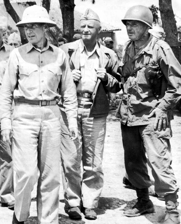
- AMERICAN COMMANDERS in Operation ICEBERG: Admiral Raymond A. Spruance,
- Fleet Admiral Chester W. Nimitz, and Lt. Gen. Simon B. Buckner.
-
- [18]
- posts in the Pacific-lessons of cooperation
and combined striking power of the services, of the technique of amphibious
operations, and of Japanese tactics and methods of meeting them. The plan
for ICEBERG brought together an aggregate of military power-men, guns, ships,
and planes that had accumulated during more than three years of total war.
The plan called for joint operations against the inner bastion of the Japanese
Empire by the greatest concentration of land, sea, and air forces ever used
in the Pacific.
-
- Basic Features of the Plan
- The immediate task imposed upon the
American forces by the terms of the general mission was the seizure and development
of Okinawa and the establishment of control of the sea and air in the Ryukyus.
The campaign was divided into three phases. The seizure of southern Okinawa,
including Keise Shima and islands in the Kerama Group, and the initiation
of the development of base facilities were to constitute the first phase.
In the next phase Ie Shima was to be occupied and control was to be established
over northern Okinawa. The third phase consisted of the seizure and development
of additional islands in the Nansei Shoto for use in future operations. The
target date of the operation was set at 1 March 1945. 26
-
- Planning began in October 1944. The
general scheme for Operation ICEBERG was issued in the fall of 1944 by Admiral
Nimitz as Commander in Chief, Pacific Ocean Areas (CINCPOA). The strategic
plan outlined was based on three assumptions. First, the projected campaign
against Iwo Jima would have progressed to such an extent that naval fire-support
and close air-support units would be available for the assault on Okinawa.
Second, the necessary ground and naval combat units and assault shipping engaged
in the Philippines would be released promptly by General MacArthur for the
Okinawa campaign. Third, preliminary air and naval operations against the
enemy would ensure control of the air in the area of the target during the
operation.27
-
- Air superiority was the most important
factor in the general concept of the operation as outlined by Admiral Nimitz's
staff. The CINCPOA planners believed that American air attacks on Japan, from
carriers and from airfields in the Marianas, combined with the seizure of
Iwo Jima, would force a concentration of enemy air strength around the heart
of the Empire-on the home islands, Formosa, the China coast, and the Ryukyus.
From these bases, strong
- [19]
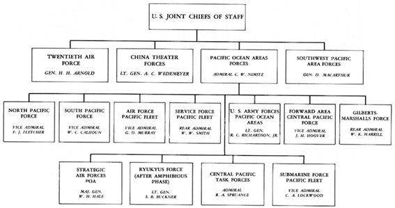
- Organization of Allied Forces for the Ryukyus Campaign,
- January 1945
-
- Source: Commander in Chief, U.S. Pacific Fleet and Pacific Ocean Areas,
Operations in the
- Pacific Ocean Areas, April 1945, Plate I, opp. p. 76 (with adaptations).
-
- [20]
- and continuous air attacks would be
made against the forces invading the Ryukyus. It would be necessary, therefore,
to neutralize or destroy enemy air installations not only at the target but
also at the staging areas in Kyushu and Formosa. All available carrier- and
land-based air forces would be called on to perform this task and give the
Americans the control of the air required in the area of operations. On Okinawa
itself, the scheme of maneuver of the ground troops would be such as to gain
early use of airfields that would enable landbased planes to maintain control
of the air in the target area. Control of the sea was to be maintained by
submarine, surface, and air attacks on enemy naval forces and shipping. 28
-
- The American Forces
- The isolation of Okinawa was to be
effected with the aid of land-based air forces of commands outside the Pacific
Ocean Areas (POA). Planes from the Southwest Pacific Area (SWPA) were to engage
in searches and continuous strikes against Formosa as soon as the situation
on Luzon permitted. Twentieth Air Force B-29's from China and the Marianas
were to bomb Formosa, Kyushu, and Okinawa during the month preceding the landings.
The China-based XX Bomber Command was to concentrate on Formosa, while the
XXI Bomber Command from the Marianas would attack Okinawa and then shift to
Kyushu and other vulnerable points in the home islands during the fighting
on Okinawa. The Fourteenth Air Force was to conduct searches along the China
coast and also, if practicable, bomb Hong Kong.29
-
- All the forces in Admiral Nimitz's
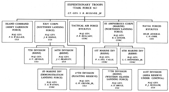
command were marshaled in support of the ICEBERG Operation. (See Chart 1.)
The Strategic Air Forces, POA, was assigned the task of neutralizing enemy
air bases in the Carolines and the Bonins, of striking Okinawa and Japan when
practicable, and of providing fighter cover for Twentieth Air Force bombing
missions against Japan. The Commander, Forward Areas Central Pacific, was
to use his naval air strength to provide antisubmarine coverage, neutralize
bypassed enemy bases, and, in general, furnish logistic support. Provision
of intelligence on enemy naval units and interdiction of the sea approaches
from Japan and Formosa were the tasks of the Submarine Force, Pacific Fleet.
The enemy was to be contained in the North Pacific Area, and the lines of
communication were to be secured in the Marshalls-Gilberts area. Logistic
support was to be provided by General Rich-
- [21]
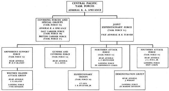
- Organizations of Central Pacific Task Forces for the Ryukyus Campaign,
- January 1945
-
- Source: Commander in Chief, U.S. Pacific Fleet and Pacific Ocean Areas,
Operations in the
- Pacific Ocean Areas, April 1945, Plates I and II, opp. p. 76 (with adaptations).
-
- [22]
- ardson's United States Army Forces,
POA (USAFPOA), the Air and Service Forces, Pacific Fleet, and the South Pacific
Force. All the armed forces in the Pacific Ocean Areas, from the West Coast
to Ulithi and from New Zealand to the Aleutians, were directed to support
the attack on Okinawa.30
-
- The principal mission in seizing the
objective was assigned to a huge joint Army-Navy task force, known as the
Central Pacific Task Forces and commanded by Admiral Raymond A. Spruance,
Commander of the Fifth Fleet. (See Chart II.) Admiral Spruance's forces consisted
of naval covering forces and special groups (Task Force 50), which he personally
commanded, and a joint Expeditionary Force (Task Force 51), commanded by Vice
Admiral Richmond K. Turner, Commander, Amphibious Forces Pacific Fleet. General
Buckner, Commanding General, Tenth Army, was to lead the Expeditionary Troops
(Task Force 56) under Admiral Turner's direction.31
-
- Command relationships prescribed for
the operation differed in some respects from those in previous operations
against island positions remote from Japan. Because the campaign would entail
prolonged ground combat activities by a field army on a large island close
to the enemy's homeland, it was necessary to define clearly the relationships
between Army and Navy commanders for the successive phases of the operation.
Admiral Nimitz accordingly provided that initially the chain of command for
amphibious operations would be Admiral Spruance, Admiral Turner, General Buckner.
However, when Admiral Spruance determined that the amphibious phases of the
operation had been successfully completed, General Buckner was to assume
command of all forces ashore. He was thereafter to be directly responsible
to Admiral Spruance for the defense and development of the captured positions.
In time, Admiral Spruance would be relieved by Admiral Nimitz of these responsibilities,
and General Buckner would take over complete command of the forces in the
Ryukyus. As Commander, Ryukyus Force, a joint task force of ground, air, and
naval garrison troops, he would be responsible only to CINCPOA for the defense
and development of the newly won bases and for the protection of the sea areas
within twenty-five miles.32
-
- Admiral Spruance, as commander of
Task Force 50, had at his disposal Vice Admiral Mitscher's Fast Carrier Force
(Task Force 58), a British Carrier Force
- [23]
- Organization of Expeditionary Troops for the Ryukyus Campaign,
- January 1945
- Source: Commander Task Force 51, Commander Amphibious Forces, U. S.
Pacific Fleet, Report on Okinawa Gunto Operations from February 17 May
to 17 May 1945, Part 1, pp. 2-4; Tenth Army Action Report Ryukyus, 26
March to 30 June 1945, Ch. 2; Commander in Chief, U.S. Pacific Fleet and
Pacific Ocean Areas, Operation in the pacific Ocean Areas, April 1945.
- [24]
- (Task Force 57), special task groups
for aerial search and reconnaissance and antisubmarine warfare, and fleet
logistic groups. Task Force 58 had a major share of the mission of neutralizing
Japanese air strength. Its fast carriers were to strike Kyushu, Okinawa, and
adjacent islands in the middle of March, to remain in a covering position
east of the target area during the week preceding the invasion, to support
the landings with strikes and patrols, and to be prepared for further forays
against Kyushu, the China coast, or threatening enemy surface forces. The
British carriers, the first to participate in Pacific naval actions with the
American fleet, were given the task of neutralizing air installations on the
Sakishima Group, southwest of the Ryukyus, during the ten days before the
landings. 33
-
- The Joint Expeditionary Force (Task
Force 51) was directly charged with the capture and development of Okinawa
and other islands in the group. It was a joint task force of Army, Navy, and
Marine units and consisted of the Expeditionary Troops (Task Force 56-see
Chart III), shipping to transport them, and supporting naval and air units.
Direct naval and air support for Task Force 51 was to be furnished by its
Amphibious Support Force (Task Force 52), made up of escort carriers, gunboat
and mortar flotillas, mine sweepers, and underwater demolition teams, and
by the Gunfire and Covering Force (Task Force 54) of old battleships, light
and heavy cruisers, destroyers, and destroyer escorts. The transports and
tractor units of the Northern Attack Force (Task Force 53) and Southern Attack
Force (Task Force 55) were to land the ground troops in the main assault on
the Okinawa beaches, while a number of task groups were assigned the task
of transporting the troops for subsidiary landings and the floating and area
reserves. Task Force 51 also included a transport screen, a service and salvage
group, and several specialized naval units. 34
-
- The troops who would assault the objectives
constituted a field army, the Tenth Army, which had been activated in the
United States in June 1944 and shortly thereafter had opened headquarters
on Oahu. General Buckner formally assumed command in September 1944, having
come to the new assignment from the command of the Alaskan Department, where
for four years he had been organizing the American defenses in that area.
His new staff included many officers who had served with him in Alaska as
well as some from the European Theater of Operations. The major components
of Tenth Army were
- [25]
- XXIV Army Corps and III Amphibious
Corps (Marine). The former consisted of the 7th and 96th Infantry Divisions
and was commanded by Maj. Gen. John R. Hodge, a veteran leader of troops who
had met and defeated the Japanese on Guadalcanal, New Georgia, Bougainville,
and Leyte. III Amphibious Corps included the 1st and 6th Marine Divisions
and was headed by Maj. Gen. Roy S. Geiger, who had successfully directed Marine
operations on Bougainville and Guam. Three divisions, the 27th and 77th Infantry
Divisions and the 2d Marine Division, were under the direct control of Tenth
Army for use in special operations and as reserves. The area reserve, the
81st Infantry Division, was under the control of CINCPOA. Also assigned to
Tenth Army for the purpose of defense and development of the objectives were
a naval task group, the Tactical Air Force, and the Island Command. 35
-
- A total of 183,000 troops was made
available for the assault phases of the operation.36
About 154,000 of these were in the seven combat divisions, excluding the 81st
Division, which remained in New Caledonia; all seven divisions were heavily
reinforced with tank battalions, amphibian truck and tractor battalions, joint
assault signal companies, and many attached service units. The five divisions
committed to the initial landings totaled about 116,000. The 1st and 6th Marine
Divisions, with 26,274 and 24,356 troops, respectively, each carried an attached
naval construction battalion and about 2,500 replacements in addition to their
other supporting combat and service units. The reinforced 7th, 77th, and 96th
Divisions averaged nearly 22,000 men per division but each was about 1,000
understrength in organic infantry personnel. The 27th, a reserve division,
was reinforced to a strength of 16,143 but remained nevertheless almost 2,000
understrength organically. The 2d Marine Division, also in Army reserve, numbered
22,195.37
(See Appendix C, Table No. 4)
-
- Tenth Army, as such, had never directed
any campaigns, but its corps and divisions had all been combat-tested before
the invasion of the Ryukyus. XXIV Corps had carried out the conquest of Leyte,
and III Amphibious Corps had captured Guam and Peleliu. The 7th Division had
seen action on Attu, Kwajalein, and Leyte, the 77th on Guam and Leyte, and
the 96th on Leyte. The 27th had taken part in the battles for the Gilberts
and Marshalls and for
- [26]
- Saipan. The 1st Marine Division had
been one of the first to see action in the Pacific, on Guadalcanal, and had
gone through the campaigns of Western New Britain and Peleliu. The 6th Marine
Division had been activated late in 1944, but its regiments were largely made
up of seasoned units that had fought on Guam, the Marshalls, and Saipan. The
ad Marine Division had participated in the fighting on Guadalcanal, Tarawa,
Saipan, and Tinian.
-
- Plan for the Capture of Okinawa
- Using the CINCPOA Toint Staff Study
as a basis, each of the major commanders prepared his plans and issued his
operation orders. Although each plan and operation order was derived from
that of the next superior echelon, planning was always concurrent. The joint
nature of the operation also required extensive coordination of the three
services in all operational and logistical problems. Joint conferences thrashed
out problems of troop lists, shipping, supplies, and strategy. Corps and task
force commanders worked together on the plans for amphibious operations. Corps
and division staffs were consulted and advised by Army for purposes of orientation
and planning. To ensure inter-service coordination, Navy and Marine officers
were assigned to work with Tenth Army general and special staff sections.38
In some cases planning was facilitated by utilizing the results of work on
other operations. Thus the naval staff developing the gunfire support plans
was able to use the operations at Iwo Jima to test and strengthen the general
command and communications framework, which was generally similar for both
operations; in the same way Tenth Army logistical planners took advantage
of their work on the canceled Formosa operation, adapting it to the needs
of the Okinawa campaign.39
-
- Out of these planning activities came
extremely important decisions that modified and expanded the scope of proposed
operations. Tenth Army found it necessary to enlarge the troop list by about
70,000 to include greater numbers of supporting combat elements and service
units. Its staff presented and supported a plan for initial assault landings
on the west coast of Okinawa, just north and south of Hagushi, as the most
feasible logistically and as consonant tactically with the requirements of
CINCPOA. The naval staff insisted on the necessity of a sustained week-long
naval bombardment of the target and on the consequent need for a protected
anchorage in the target area where the fleet units could refuel and resupply.
As a result it was decided to capture the Kerama Islands
- [27]
- just west of Okinawa, a week before
the main landings, and the 77th Division was assigned this task. At the suggestion
of Admiral Turner a landing was to be feinted on the eastern coast of the
island, and the 2d Marine Division was selected for this operation. The commitment
of these two reserve divisions impelled Tenth Army to secure the release of
the area reserve division to the Expeditionary Troops, and the 27th Division
was designated the floating reserve. In its place, as area reserve, the first
Division was ordered to stand by in the South Pacific. Finally, CINCPOA was
twice forced to set back the target date because delays in the Luzon operation
created difficulty in maintaining shipping schedules and because unfavorable
weather conditions appeared likely in the target area during March. L Day
(landing day) was set for 1 April 1945.40
-
- As finally conceived, the plan for
the capture of Okinawa gave fullest opportunity for the use of the mobility,
long range, and striking power of combined arms. After the strategic isolation
of Okinawa had been effected by land- and carrier-based aircraft, the amphibious
forces were to move forward to the objective. Task Force 52 (the Amphibious
Support Force) and Task Force 54 (the Gunfire and Covering Force), assisted
by the fast carriers of Task Force 58, were to begin operations at Okinawa
and the Kerama Group on L minus 8 (24 March). They were to destroy the enemy
defenses and air installations by naval gunfire and air strikes, clear the
waters around the objective and the beaches of mines and other obstacles,
and provide cover and protection against hostile surface and air units to
ensure the safe and uninterrupted approach of the transports and the landings
of the assault troops. After the landings they were to furnish naval support
and air cover for the land operations.41
-
- Mine sweepers were to be the first
units of the Amphibious Support Force to arrive in the target area. Beginning
on L minus 8, they were to clear the way for the approach of the bombardment
units and then to sweep the waters in the landing and demonstration areas
to the shore line.42
Underwater demolition teams were to follow the mine sweepers, reconnoiter
the beaches, and demolish beach obstacles.43
-
- Naval gunfire was to support the capture
of Okinawa by scheduled destructive bombardment in the week before the landings,
by intensive close support
- [28]
- of the main and subsidiary landings
and the diversionary feint, and thereafter by delivering call and other support
fires. The fire support ships with their 5- to 16-inch guns were organized
into fire support units, each consisting of 2 old battleships, 2 or 3 cruisers,
and 4 or 5 destroyers, that were to stand off the southern part of the island
in accordance with definite areas of responsibility. In view of the size of
the objective and the impossibility of destroying all targets, fire during
the prelanding bombardment was to be laid on carefully selected targets; the
principal efforts were to be directed to the destruction of weapons threatening
ships and aircraft and of the defenses opposing the landings. Profitable targets
were at all times to be sought by close observation, exploratory firing, and
constant evaluation of results. Covering fires were to be furnished in conjunction
with fire from gunboats and mortar boats in support of mine-sweeping operations
and beach demolitions.44
-
- On L Day, beginning at 0600, the naval
guns were to mass their fires on the beaches. Counterbattery and deep supporting
fires were to destroy the defense guns and keep enemy reinforcements from
moving up to oppose the landings. As the assault waves approached the beaches,
the fires of the big guns would lift to targets in critical areas inland and
to the exterior flanks of the troops. Mortar boats and gunboats were to lead
the boat waves to the shore, delivering mortar and rocket fire on the beaches.
All craft would begin 40-mm. fire on passing the line of fire support ships
and would fire at will until H Hour.45
After the landings scheduled fire on areas 1,000 yards inland and on the flanks
would be continued, but top priority would be given to call fires in direct
support of the assault elements.46
-
- All scheduled bombardments until H
minus 35 minutes were to be under control of the commander of Task Force 52.
After that time, because of the size of the landing forces and the extent
of the beaches, the commanders of the Northern and Southern Attack Forces
would assume control of the support of their respective landing forces. The
commander of Task Force 51 was to remain responsible for the general coordination
as well as the actual control of bombardment in the Army zone. By 1500 each
day he would allocate gunfire support vessels for the succeeding twenty-four
hours in accordance with approved requests from Army and Corps.47
- [29]
- MAP NO. 3
- [30]
- Air support was to be provided largely
by the fast carriers of Task Force 58 and by the escort carriers of Task Force
52. The fast carriers were for the first time to be available at the target
area for a prolonged period to furnish support and combat air patrols. They
were to cover mine-sweeping operations, hit targets on Okinawa which could
not be reached by naval gunfire, destroy enemy defenses and air installations,
and strafe the landing beaches. The escort carriers would provide aircraft
for direct support missions, antisubmarine patrols, naval and artillery gunfire
spotting, air supply, photographic missions, and the dropping of propaganda
leaflets. After L Day additional support was to be furnished by seaplane squadrons
based on the Kerama Islands and by the shorebased Tactical Air Force of the
Tenth Army.48
The latter was eventually to be responsible for the air defense of the area,
being charged with gaining the necessary air superiority and giving tactical
support to the ground troops.49
-
- Provision was made for the careful
coordination of all naval gunfire, air support, and artillery both in the
assault and in the campaign in general. Target information centers, to be
established at army, corps, and division levels, would collect and disseminate
data on all targets suitable for attack by the respective arms and keep a
record of attacks actually carried out. In addition, at every echelon, from
battalion to army, representatives of each support arm-artillery, naval gunfire,
and air-were to coordinate the use of their respective arms for targets in
their zones of action and advise their commanders on the proper employment
of the various types of supporting fires. Requests for support would thus
be coordinated and screened as they passed up through the various echelons
for approval.50
-
- Under cover of the sustained day and
night attacks by the naval and air forces, the first phase of the campaign-the
capture of the Kerama and Keise Islands and of the southern part of Okinawa-was
to begin. On L minus 6, the Western Islands Attack Group was to land the reinforced
77th Division on the Kerama Islands. The seizure of these islands was designed
to give the joint Expeditionary Force, prior to the main assault on Okinawa
proper, a base for logistic support of fleet units, a protected anchorage,
and a seaplane base. Two regimental combat teams were to land on several of
the islands simultaneously and to proceed from the southeast end of the group
to the northeast by island-
- [31]
- hopping maneuvers, capturing Keise
Island by L minus 1. All hostile coastal defense guns that could interfere
with the construction of the proposed naval bases were to be destroyed. Organized
enemy forces would be broken up without attempting to clear the islands of
snipers. Two battalions of 155-mm. guns were to be emplaced on Keise in order
to give artillery support to the landings on the coast of Okinawa. Then, after
stationing a small garrison force in the islands, the division would reembark
and be prepared to execute the Tenth Army's reserve plans, giving priority
to the capture of Ie Shima 51
(See Map No. 3.)
-
- While the 77th Division was taking
the lightly held Kerama Islands, the preliminary operations for softening
up Okinawa would begin; they would mount in intensity as L Day approached.
Beginning on 28 March fire support units would close in on the island behind
the mine sweepers and demolition teams. The Northern and Southern Attack Forces
would arrive off the west coast early on L Day and land their respective ground
forces at H Hour, tentatively set for 0830. III Amphibious Corps would land,
two divisions abreast, on the left flank, north of the town of Hagushi at
the mouth of the Bishi River XXIV Corps would land, two divisions abreast,
on the right flank, south of Hagushi. The four divisions in landing would
be in the following order from north to south; 6th Marine Division, 1st Marine
Division, 7th Division; and 96th Division. The two corps were then to drive
across the island in a coordinated advance. The 6th Marine Division was first
to capture the Yontan airfield and then to advance to the Ishikawa Isthmus,
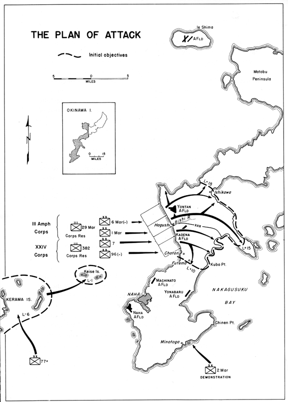
the narrow neck of the island, securing the beachhead on the north by L plus
15. The 1st Marine Division was to head across the island and drive down the
Katchin Peninsula on the east coast. South of the Corps' boundary, which ran
eastward from the mouth of the Bishi, the 7th Division would quickly seize
the Kadena airfield and advance to the east coast, cutting the island in two.
The 96th was required initially to capture the high ground commanding its
beaches on the south and southeast; then it was to move rapidly down the coastal
road, capture the bridges near Chatan, and protect the right of the Corps.
Continuing its attack, it was to pivot on its right flank to secure the beachhead
on the south by L plus 10 on a line running across the isthmus below Kuba
and Futema.52
-
- The choice of the beaches north and
south of Hagushi for the initial assault was made after a study by Tenth Army
of all the landing beaches in southern
- [32]
- Okinawa and a survey of several plans
of action. The various plans were weighed in the light of the requirements
of the CINCPOA Joint Staff Study and considerations of tactical and logistical
feasibility. The preferred plan was finally chosen for a number of reasons.
First, it would secure the necessary airfields by L plus 5. Second, it would
provide the unloading facilities to support the assault. The Hagushi beaches
were considered the only ones capable of handling sufficient tonnage to sustain
a force of two corps and supporting troops, and this seemed to outweigh the
disadvantages of not providing for the early capture of the port of Naha and
the anchorage in Nakagusuku Bay. Third, the plan would result in separating
the enemy forces. Fourth, it would concentrate the troops on one continuous
landing beach opposite the point where the greatest enemy resistance was expected.
Fifth, it would use the terrain least advantageous for enemy resistance to
the landings. Finally, it would permit maximum fire support of the assault.53
-
- The scheme of maneuver was designed
to isolate the initial objective, the southern part of the island, by seizing
the Ishikawa Isthmus, north of the landing beaches, to prevent enemy reinforcement
from that direction. At the same time the establishment of a general east-west
line from Kuba on the south would prevent reinforcement from the south. Thereafter,
the attack was to be continued until the entire southern part of the island
was occupied.54
Ground commanders hoped that, for the first time in the Pacific, maneuver
could be used to the utmost. The troops would cut across the island quickly,
move rapidly to the south, break up the Japanese forces into small segments,
bypass strong points, and mop up at leisure.55
-
- While the troops were landing on the
west coast, the 2d Marine Division would feint landings on the southeast coast.
This demonstration, scheduled for L Day and to be repeated on L plus 1, would
be as realistic as possible in order to deceive the enemy into believing that
landings would be made there as well as on the Hagushi beaches. After the
demonstration the division would be prepared to land on the Hagushi beaches
in support of the assault forces.56
-
- The 27th Division, as floating reserve,
was to arrive at Ulithi not later than L plus 1 and be on call of the Commander,
Joint Expeditionary Force. It was
- [33]
- to be prepared to seize the islands
off the east coast of Okinawa and then to land on that coast in support of
XXIV Corps.57
-
- In case the preferred plan for landing
on the west coast proved impracticable, an alternate plan was to be used.
In this plan, the capture of the Kerama Islands was to be followed by a similar
sweep through the small islands east of southern Okinawa that guarded the
entrance to Nakagusuku Bay. On L Day two Marine divisions would land on the
southeast coast of Okinawa, between Chinen Point and the town of Minatoga.
During the next three days the marines were to seize high ground in the area
in order to support a landing by two divisions of XXIV Corps on the lower
part of Nakagusuku Bay, between Kuba and Yonabaru. Although the alternate
plan met most of the requirements for a successful landing operation, it was
distinctly a second choice because it would allow the enemy reserves to offer
maximum opposition to the second landings and would require a prolonged assault
against all the enemy forces on the island to complete the first phase of
the mission.58
-
- Psychological Warfare and Military
Government
- Despite general skepticism as to the
effectiveness of psychological warfare against the Japanese,59
an attitude which resulted from its failure in many previous operations, the
American plan called for an intensive effort to weaken the enemy's will to
resist. Intelligence agencies prepared 5,700,000 leaflets to be dropped over
Okinawa from carrier planes. More millions of leaflets were to be printed
at the target and scattered over specific areas by bombs and shells. Tanks
with amplifiers, an airplane with an ultraloud speaker, and remotely controlled
radios dropped behind enemy lines would also tell the enemy why and how he
should surrender.60
-
- The plans for psychological warfare
were also directed toward influencing the Okinawans, and in this connection
there was greater optimism. Because the Okinawans were of a different stock
and culture from the Japanese, and had been treated by their rulers as inferiors
rather than as elements to be assimilated to Japanese nationalism and militarism,
it was hoped that the civilians would not be as hostile, or at any rate as
fanatical, as the Japanese.
- [34]
- The Okinawans also presented the American
planners with the problem of military government. The problem was twofold-that
of removing the Okinawans from the front lines and that of caring for them;
it was necessary to handle the problem in such a way as to facilitate military
operations and to make available to the occupying forces the labor and economic
resources of the areas. Approximately 300,000 natives lived in southern Okinawa;
thousands of others were in the north and on near-by islands. Never before
in the Pacific had Americans faced the task of controlling so many enemy civilians.
-
- Basic responsibility for military
government in the conquered Japanese islands devolved on the Navy, and Admiral
Nimitz was to assume the position of Military Governor of the Ryukyus. However,
in view of the fact that most of the garrison forces were Army troops, Admiral
Nimitz delegated the responsibility to General Buckner. The latter planned
to control military government operations during the assault phase through
his tactical commanders; corps and division commanders were made responsible
for military government in the areas under their control and were assigned
military government detachments whose mission was to plan and organize civilian
activities behind the fighting fronts. As the campaign progressed and increasing
numbers of civilians were encountered, teams attached to military government
headquarters of Tenth Army would assume charge, organize camps, and administer
the program on an island-wide basis. During the garrison phase the Island
Commander, on order of General Buckner, would exercise command over all military
government personnel. Maj. Gen. Fred C. Wallace would act through a Deputy
Commander for Military Government, Brig. Gen. W. E. Crist 61
-
- The major problem of Military Government
was to feed and provide emergency medical care for the approximately 300,000
civilians who were expected to be within the American lines by L plus 40.
Each of the combat divisions mounted out with 70,000 civilian rations of such
native staples as rice, soy beans, and canned fish and also with medical supplies.
Military Government personnel would land in the wake of assault units to handle
a huge "disaster relief" program. Additional supplies of all kinds
were to be included in the general maintenance shipments.62
- [35]
-
- Organizing the Supply Line
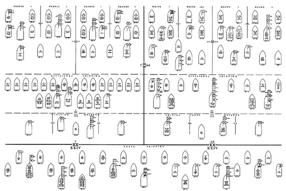
- The planning and execution of ICEBERG
presented logistical problems of a magnitude greater than any previously encountered
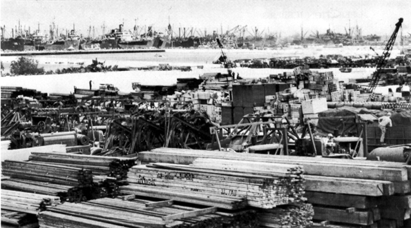
in the Pacific. For the assault echelon alone, about 183,000 troops and 747,000
measurement tons of cargo were loaded into over 430 assault transports and
landing ships at 11 different ports, from Seattle to Leyte, a distance of
6,000 miles. (See Appendix C, Tables Nos. 4 and 5.) After the landings, maintenance
had to be provided for the combat troops and a continuously increasing garrison
force that eventually numbered 270,000. Concurrently, the development of Okinawa
as an advanced air and fleet base and mounting area for future operations
involved supply and construction programs extending over a period of many
months subsequent to the initial assault. Close integration of assault, maintenance,
and garrison shipping and supply was necessary at all times.63
-
- Factors of distance dominated the
logistical picture. Cargo and troops were lifted on the West Coast, Oahu,
Espiritu Santo, New Caledonia, Guadalcanal, the Russell Islands, Saipan, and
Leyte, and were assembled at Eniwetok, Ulithi, Saipan, and Leyte. The closest
Pacific Ocean Area bases were at Ulithi and the Marianas, 5 days sailing time
to Okinawa (at 20 knots). The West Coast, which furnished the bulk of resupply,
was 6,250 nautical miles away, Or 26 days' sailing time. Allowing 30 days
to prepare and forward the requisitions, 60 days for procurement and loading
on the West Coast, and 30 days for sailing to the target, the planners were
faced with a 1120-day interval between the initiation of their calculations
and the arrival of supplies. This meant in practice that requisitioning had
to be started before a Troop Basis had been fixed and the details of the tactical
plans worked out. Distance, moreover, used up ships and compelled the adoption
of a schedule of staggered supply shipments, or "echelons," as well
as a number of other improvisations. Mounting the troops where they were stationed,
in the scattered reaches of the Pacific Ocean and Southwest Pacific Areas,
required close and intricate timing to have them at the target at the appointed
moment.64
-
- Broad logistic responsibilities for
the support of ICEBERG were assigned by Admiral Nimitz to the various commanders
chiefly concerned. Admiral Turner, as commander of the Amphibious Forces Pacific
Fleet, furnished the
- [36]
- shipping for the assault troops and
their supplies, determined the loading schedules, and was responsible for
the delivery of men and cargo to the beaches. General Buckner allocated assault
shipping space to the elements of his command and was responsible for landing
the supplies and transporting them to the dumps. The control of maintenance
and garrison shipping, which was largely loaded on the West Coast, was retained
by CINCPOA. Responsibility for both the initial supply and the resupply of
all Army troops was assigned to the Commanding General, Pacific Ocean Areas,
while the Commanders, Fleet Marine Force, Service Force, and Air Force of
the Pacific Fleet were charged with logistic support of Marine, Navy, and
naval aviation units. The initial supplies for the troops mounting in the
South Pacific and the Southwest Pacific were to be furnished by the commanders
of those areas.65
-
- The first phase of supply planning
involved the preparation of special lists of equipment required for the operation,
which included excess Tables of Equipment items, equipment peculiar to amphibious
operations, and base development materials. Such lists, or operational projects
as they were known, had been prepared for the projected Formosa operation;
when this was canceled the projects were screened and reduced to meet the
needs of ICEBERG.66
-
- At a very early stage in the planning
it became evident that there was a shortage of available shipping. The number
of combat and service troops included in the initial Troop Basis far exceeded
the capacity of allocated shipping. As a result, tonnage had to be reduced
for some units while other units were eliminated entirely from the assault
echelon and assigned space in the next echelon. Later, in January 1945, it
became apparent that there was still not enough shipping space in the assault
echelon to transport certain air units and base development materials designed
for early use. It was necessary to request CINCPOA to increase the over-all
allocation of LST's and LSM's, as well as to curtail cargo tonnage and provide
for the quick return of LST's to Saipan to load eight naval construction battalions.67
-
- Providing the assault troops with
their initial supplies was not a difficult problem as generally there were
sufficient stocks on hand at each of the mounting areas. When the assault
units embarked, they took with them a 30-day supply of rations, essential
clothing and equipment, fuel, and medical and construction
- [37]
- supplies. Initial ammunition quotas
consisted of five CINCPOA units of fire.68
On Leyte, XXIV Corps found that SWPA logistics agencies did not have sufficient
rations on hand to supply it as required, and the shortage was overcome by
having the Corps joined at Okinawa by two LST's loaded with rations from Tenth
Army reserve stocks in the Marianas.69
-
- Equipment issued to the troops included
weapons and instruments of war never before used against the Japanese.
New-type flame-thrower tanks, with an increased effective range and a larger
fuel capacity, were available for the invasion. Each division was issued 110
sniperscopes and 140 snooperscopes, devices for seeing in the dark by means
of infrared radiation; the former were mounted on carbines and permitted accurate
night firing, while the latter were on hand-held mounts and could be used
for night observation and signaling. Army artillery and antiaircraft units
used proximity (VT) fuzes over land areas for the first time in the Pacific.
During the campaign tests were conducted with a new mortar-locating device,
the Sound Locator Set GR-6, and the 57-mm.. and 75-mm. recoilless rifles and
4.2-inch recoilless mortars.70
-
- Supplies to maintain the troops at
the target were scheduled to arrive twenty-one shipments from the West Coast.
Loaded ships were to sail from Pacific ports at 10-day intervals, beginning
on L minus 40 (20 February 1945), and to arrive at the regulating stations
at Ulithi and Eniwetok beginning , L minus 5, there to await the call of General
Buckner. These maintenance; shipments, planned to provide automatic resupply
until L plus 210 (31 October 1945), were based on the estimated population
build-up at the scheduled time of arrival. The principal emergency reserves
were kept at Saipan and Guan. 71
-
- The main logistical task of the operation,
in Admiral Nimitz's opinion, v. the rapid development of air and naval bases
in the Ryukyus to support further operations against Japan. The Base Development
Plan for Okinawa, published by CINCPOA, provided for the construction of eight
airfields on Okinawa, two of which were to be operational by L plus 5, a seaplane
base, an advanced fleet.
- [38]
- base at Nakagusuku Bay, and the rehabilitation
of the port of Naha to accommodate support shipping. Base development responsibilities
also included immediate support of the assault by the early construction of
tank farms for the bulk storage of fuel and for the improvement of waterfront
unloading facilities and of roads. Later a large construction program was
planned that included roads, dumps, hospitals, communications facilities,
water supply systems, and housing and recreational facilities. A plan for
the development of Ie Shima as an advanced air base was also prepared.72
-
- General Buckner was charged with the
responsibility for base development in the Ryukyus. Assigned to Tenth Army
for the execution of the Base Development Plan was the Island Command Okinawa,
or Army Garrison Force, with Maj. Gen. Fred C. Wallace in command. Some of
the Island Command troops were to land in the assault echelon and to provide
logistic support for the assault troops during and immediately after the landings.
At the conclusion of the amphibious phase, the Island Command was to act as
Tenth Army's administrative and logistical agency, operating in effect as
an Army service command and an advanced section of the communications zone.
As such, it was to be in charge of the base development program as well as
of the garrisoning and defense of the captured positions. Garrison troops
and base development materials were scheduled to arrive at Okinawa in seventeen
echelons. These were based primarily on the unloading capacity of the Hagushi
beaches; the tonnage in each echelon was kept within the estimated discharge
capacity between the arrivals of the echelons. Most of this garrison shipping
was loaded on the West Coast and Oahu, but some originated in the South Pacific
and the Marianas.73
-
- Training and Rehearsal of Troops
- The great distances that separated
the elements of its command, together with the limited time available, precluded
combined training or rehearsal by Tenth Army of the maneuver which would land
two corps abreast on a hostile shore. To the extent that circumstances permitted,
however, the scattered units of the Tenth Army engaged in individual training,
combined-arms training, and special training in amphibious, cave, and mountain
warfare. Particular efforts were made to train ground troops in the use of
the new snooperscopes
- [39]
- and sniperscopes, and the one standard
tank battalion which was converted to an armored flame thrower battalion received
instruction in the use and maintenance of its tanks. Many service units received
little specialized training because of the pressure of their regular duties
and, in some cases, the circumstance that they had been released to Tenth
Army only a few days before mounting from Hawaii.74
-
- When, in December 1944, XXIV Corps
received its warning order, it was in action over a large part of southern
Leyte, engaged in virtually separate operations on the east and west coasts
of the island. The Corps was not released from tactical responsibility until
10 February 1945, and it did not complete the assembly of all its units in
the staging area at Dulag until 18 February. Training and rehearsals had to
be sandwiched between the rehabilitation program for its combat-weary units
and the mounting-out for the new operation. The 7th, 77th, and 96th Divisions
were able to engage only in a very limited amount of training specifically
oriented to the Okinawa operation, but all managed to train in the use of
the sniperscope and of flame throwers. The Corps was, however, able to engage
in a full-scale nonfiring rehearsal with the 7th and 96th Divisions and amphibious
elements of the Southern Attack Force in Leyte Gulf from 15 to 19 March 1945.
In addition to training in the techniques of amphibious landings, the troops
practiced the breaching and scaling of sea walls. Assault regiments of the
two divisions landed and moved inland for 1,000 yards in a simulated attack,
after which critiques were held and the exercise repeated. The 77th Division
conducted practice landings separately in Leyte Gulf from 9 to 16 March. The
27th was able to engage in intensive training in Espiritu Santo between October
1944 and 25 March 1945, when it embarked for the target; four landing rehearsals
were also held between 20 and 25 March.75
-
- All the Marine divisions scheduled
for the Okinawa campaign had several months in which to train and rehearse.
The 1st Marine Division, finding training facilities restricted in the Russell
Islands, arranged for each of its regiments to take a month's training on
Guadalcanal, where adequate artillery, mortar, and small-arms ranges were
available. The 6th Marine Division trained on Guadalcanal, conducting numerous
division problems and field exercises. On Saipan the 2d Marine Division had
the advantage of practicing against the Japanese still holed up in the hills.
The III Amphibious Corps conducted a combined
- [40]
- rehearsal with the 1st and 6th Marine
Divisions at Guadalcanal from 2 to 7 March; full-scale problems were worked
out, troops and token supplies were landed, and a communications net established.76
-
- Mounting Out
- Responsibility for the loading of
the assault units was decentralized through delegation to the commanders at
the various mounting points; the Commanding General, Tenth Army, however,
retained control of the mounting of units from Oahu. The commanders of the
III Amphibious Corps and XXIV Corps were responsible for embarking their respective
troops in the South Pacific and Leyte. The 2d Marine Division supervised the
loading of its own troops and other units mounting from Saipan. Units which
originated on the West Coast were moved to the assigned mounting points for
integration with the assault echelon.77
-
- All loading was conducted according
to the transport doctrine of the Amphibious Forces Pacific Fleet and the logistical
directives published by Tenth Army. One transport squadron of fifteen APA's
(transports) and six AKA's (cargo ships), together with the requisite number
of LST's and LSM's, was allocated to each division, and additional allocations
were made for Corps and Army troops. (See Chart IV.) Altogether, 111 APA's,
47 AKA's, 184 LST's, and 89 LSM's were loaded in mounting the joint Expeditionary
Force. Transport Quartermaster Teams were activated and assigned to Army units
to load their troops and equipment, while Marine units used the teams which
had functioned in previous operations. Admiral Turner also sent two combat
loading teams, trained in embarkation procedures and familiar with the policies
of his command, to aid in the loading of the two corps at Leyte and the GuadalcanalRussells
area. and of the 27th Division at Espiritu Santo. All loading plans and operations
were subject to the approval of the captain of each ship as well as of the
transport squadron commander concerned.78
-
- Tenth Army headquarters and most of
its attached troops mounted out of Hawaii, while the 7th, 77th, and 96th Divisions
embarked at Leyte, where the largest number of ships was loaded. Each division
did its own loading under general supervision of the Corps. The chief difficulty
encountered was the necessity of loading across the open beaches in the Dulag
area on the east coast of Leyte. Piers were nonexistent or of too flimsy a
construction to withstand the battering which they took in the high surf and
tide. LST's and LSM's were
- [41]
-
- LOADING SUPPLIES FOR OKINAWA-not only arms, ammunition,
and food but also
great quantities of construction material (above). Barrels of fuel and
boxes of other
matériel are shown below being loaded at Leyte.
-
-
- [42]
- beached as near shore as possible
and vehicles had to be driven through the water; 105-mm. artillery was loaded
by means of DUKW's and ponton causeways. Transports were loaded in the stream
by ships' boats, LCT's, and LSM's. Many lighters and landing craft on Leyte
had been diverted to the needs of the Luzon campaign in February when loading
began, and a hurry call was sent to Tenth Army for additional lighterage.
Loading plans also went awry because of the lack of accurate advance information
on the characteristics of ships to be loaded. Much time was consumed by the
necessity of unloading newly arrived supplies across the open beaches and
reloading them in the assault shipping. The 27th Division loaded separately
at Espiritu Santo, where it met difficulties of transportation and misunderstandings
with naval officials.79
-
- III Amphibious Corps and its units
mounted out in the GuadalcanalRussells area. Loading was out in the stream
but was facilitated by an ample supply of lighterage and by excellent sandy
beaches. Assault troops were embarked on transports initially and were transferred
to landing ships at the staging point at Ulithi, a method which shortened
the time to be spent in the uncomfortable, crowded LST's and LSM's.80
-
- Movement to the target got under way
on 18 March 1945, when the slow tractor group carrying the assault troops
which were to take the Kerama Islands left San Pedro Bay, Leyte. Transports
with other 77th Division troops sailed from Leyte three days later, and the
remainder of the division followed on 24 March. The tractor groups of the
Southern Attack Force sailed from Leyte on 25 March, and the faster transports
followed two days later. The course from Leyte was approximately NE by N to
a point about 300 miles south of Okinawa, when it was changed to N by NW directly
to the target. Units of III Amphibious Corps in the Northern Attack Force
sailed from the Guadalcanal area on 12 March, arriving on 21 March at Ulithi,
where four days were spent in topping off supplies and effecting the transfer
of troops to landing ships. The Northern Tractor Flotilla left from Ulithi
on 25 March. The tractor groups carrying the 2d Marine Division to the demonstration
beaches left Saipan the same day. When the remainder of the Northern and Southern
Attack Forces and the Demonstration Group set forth on 27 March, Americans
and Japanese were already engaged in land fighting in the Kerama Islands.81
- [43]
- XXIV Corps Assignment of Shipping for the Assault on Okinawa
- [Click for larger image as a PDF file]
- Source: XXIV Corps Action Report Ryukyus, 1 April to 30 June 1945, chart
opp. p. 21
page created 10 December 2001
